Toppenstedt geodata
Toppenstedt (Lower Saxony) is a seat of a fourth-order administrative division; located in Germany in Europe/Berlin (GMT+2) time zone. With population of 2,122 people, there are 4900 cities with bigger population in this country. Compared to other cities in Germany, 83.4% of cities are located further ↓South; 51.8% of cities are located further ←West and 84.5% of cities have higher elevation than Toppenstedt. Note1


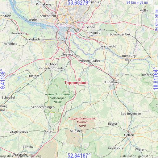
Toppenstedt GPS coordinates[2]
53° 15' 51.48" North, 10° 6' 52.236" East
| Map corner | latitude | longitude |
|---|---|---|
| Upper-left | 53.68279°, | 9.41139° |
| Center: | 53.2643°, | 10.11451° |
| Lower-right: | 52.84167°, | 10.81764° |
| Map W x H: | 93.5×93.5 km | = 58.1×58.1mi |
| max Lat: | 55.01917° ⇑16.6% North |
| Toppenstedt: | 53.2643° |
| min Lat: | ⇓83.4% South 47.40724° |
| min Long | Toppenstedt | max Long |
| 5.92978° | 10.11451° | 14.98853° |
| W 51.8%⇐ | ⇒48.2% E |
Elevation
Elevation of Toppenstedt is 36 m = 118 ft, and this is 213.1 m = 699 ft below average elevation for this country.
| Max E: |
1256 m = 4121 ft | 84.5% |
| Avg. | 249.1 m = 817 ft | |
| Toppenstedt | 36 m = 118 ft | |
Min E: |
-5 m = -16 ft | 15.5% |
See also: Germany elevation on elevation.city.
Geographical zone
Toppenstedt is located in North temperate zone (between Tropic of Cancer and the Arctic Circle). Distance of this North polar circle is 1478.7 km =918.8 mi to North.| Distance of | km | miles | from Toppenstedt |
|---|---|---|---|
| North Pole | 4084.6 | 2538.1 | to North |
| Arctic Circle | 1478.7 | 918.8 | to North |
| Tropic Cancer | 3316.5 | 2060.8 | to South |
| Equator | 5922.4 | 3680 | to South |


Nearby cities:
15 places around Toppenstedt: (largest is in red/bold)
• Asendorf
9.5 km =5.9 mi,  289°
289°
• Brackel
5.9 km =3.7 mi,  311°
311°
• Egestorf
8.6 km =5.3 mi,  203°
203°
• Eyendorf
7.5 km =4.7 mi,  161°
161°
• Garlstorf
3.1 km =1.9 mi, 196°
• Garstedt
3.9 km =2.4 mi,  53°
53°
• Gödenstorf
4 km =2.5 mi,  171°
171°
• Hanstedt
6.5 km =4 mi,  272°
272°
• Jesteburg
11.9 km =7.4 mi,  295°
295°
• Marxen
9.1 km =5.7 mi, 305°
• Salzhausen
5.9 km =3.7 mi,  141°
141°
• Undeloh
11.9 km =7.4 mi,  231°
231°
• Vierhöfen
6.8 km =4.2 mi,  87°
87°
• Westergellersen
9.6 km =6 mi,  110°
110°
• Wulfsen
4.6 km =2.9 mi,  30°
30°
Sources, notices
• [Note1] Compared only with cities in Germany existing in our database
• [Src1] Map data: © OpenStreetMap contributors (CC-BY-SA)
• [Src2] Other city data from geonames.org with taken over terms of usage.
• [Src3] Geographical zone / Annual Mean Temperature by Robert A. Rohde @ Wikipedia
