Brackel geodata
Brackel (Lower Saxony) is a seat of a fourth-order administrative division; located in Germany in Europe/Berlin (GMT+2) time zone. With population of 1,653 people, there are 5596 cities with bigger population in this country. Compared to other cities in Germany, 83.7% of cities are located further ↓South; 50.8% of cities are located further ←West and 80.6% of cities have higher elevation than Brackel. Note1


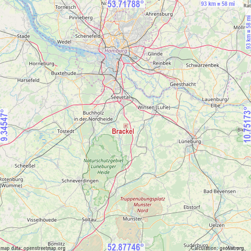
Brackel GPS coordinates[2]
53° 17' 59.064" North, 10° 2' 54.96" East
| Map corner | latitude | longitude |
|---|---|---|
| Upper-left | 53.71788°, | 9.34547° |
| Center: | 53.29974°, | 10.0486° |
| Lower-right: | 52.87746°, | 10.75173° |
| Map W x H: | 93.4×93.4 km | = 58×58mi |
| max Lat: | 55.01917° ⇑16.3% North |
| Brackel: | 53.29974° |
| min Lat: | ⇓83.7% South 47.40724° |
| min Long | Brackel | max Long |
| 5.92978° | 10.0486° | 14.98853° |
| W 50.8%⇐ | ⇒49.2% E |
Elevation
Elevation of Brackel is 45 m = 148 ft, and this is 204.1 m = 670 ft below average elevation for this country.
| Max E: |
1256 m = 4121 ft | 80.6% |
| Avg. | 249.1 m = 817 ft | |
| Brackel | 45 m = 148 ft | |
Min E: |
-5 m = -16 ft | 19.4% |
See also: Germany elevation on elevation.city.
Geographical zone
Brackel is located in North temperate zone (between Tropic of Cancer and the Arctic Circle). Distance of this North polar circle is 1474.8 km =916.4 mi to North.| Distance of | km | miles | from Brackel |
|---|---|---|---|
| North Pole | 4080.7 | 2535.6 | to North |
| Arctic Circle | 1474.8 | 916.4 | to North |
| Tropic Cancer | 3320.5 | 2063.3 | to South |
| Equator | 5926.4 | 3682.5 | to South |


Nearby cities:
15 places around Brackel: (largest is in red/bold)
• Asendorf
4.7 km =2.9 mi,  260°
260°
• Bendestorf
7 km =4.3 mi,  304°
304°
• Egestorf
11.9 km =7.4 mi,  175°
175°
• Garlstorf
7.8 km =4.8 mi,  153°
153°
• Garstedt
7.7 km =4.8 mi,  102°
102°
• Gödenstorf
9.4 km =5.8 mi, 147°
• Hanstedt
4.2 km =2.6 mi,  209°
209°
• Harmstorf
7.1 km =4.4 mi,  322°
322°
• Jesteburg
6.5 km =4 mi,  279°
279°
• Marxen
3.3 km =2.1 mi,  294°
294°
• Salzhausen
11.7 km =7.3 mi,  136°
136°
• Stelle
10.3 km =6.4 mi,  23°
23°
• Toppenstedt
5.9 km =3.7 mi,  131°
131°
• Vierhöfen
11.8 km =7.3 mi,  108°
108°
• Wulfsen
6.7 km =4.2 mi,  89°
89°
Sources, notices
• [Note1] Compared only with cities in Germany existing in our database
• [Src1] Map data: © OpenStreetMap contributors (CC-BY-SA)
• [Src2] Other city data from geonames.org with taken over terms of usage.
• [Src3] Geographical zone / Annual Mean Temperature by Robert A. Rohde @ Wikipedia
