Asendorf geodata
Asendorf (Lower Saxony) is a seat of a fourth-order administrative division; located in Germany in Europe/Berlin (GMT+2) time zone. With population of 1,809 people, there are 5333 cities with bigger population in this country. Compared to other cities in Germany, 83.6% of cities are located further ↓South; 50.4% of cities are located further →East and 84.1% of cities have higher elevation than Asendorf. Note1


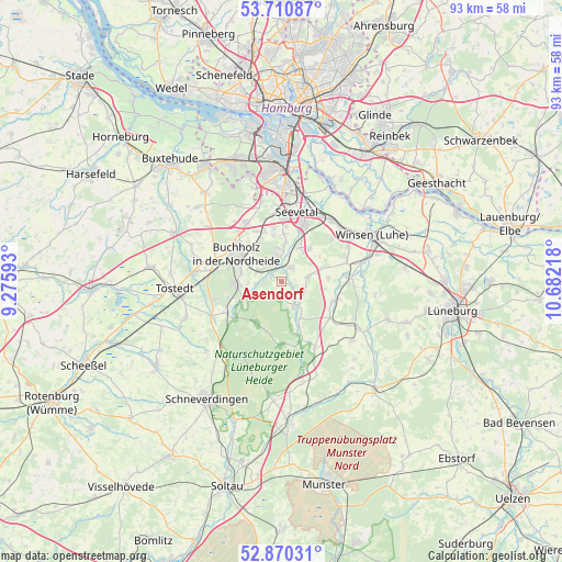
Asendorf GPS coordinates[2]
53° 17' 33.576" North, 9° 58' 44.58" East
| Map corner | latitude | longitude |
|---|---|---|
| Upper-left | 53.71087°, | 9.27593° |
| Center: | 53.29266°, | 9.97905° |
| Lower-right: | 52.87031°, | 10.68218° |
| Map W x H: | 93.5×93.5 km | = 58.1×58.1mi |
| max Lat: | 55.01917° ⇑16.4% North |
| Asendorf: | 53.29266° |
| min Lat: | ⇓83.6% South 47.40724° |
| min Long | Asendorf | max Long |
| 5.92978° | 9.97905° | 14.98853° |
| W 49.6%⇐ | ⇒50.4% E |
Elevation
Elevation of Asendorf is 37 m = 121 ft, and this is 212.1 m = 696 ft below average elevation for this country.
| Max E: |
1256 m = 4121 ft | 84.1% |
| Avg. | 249.1 m = 817 ft | |
| Asendorf | 37 m = 121 ft | |
Min E: |
-5 m = -16 ft | 15.9% |
See also: Germany elevation on elevation.city.
Geographical zone
Asendorf is located in North temperate zone (between Tropic of Cancer and the Arctic Circle). Distance of this North polar circle is 1475.6 km =916.9 mi to North.| Distance of | km | miles | from Asendorf |
|---|---|---|---|
| North Pole | 4081.5 | 2536.1 | to North |
| Arctic Circle | 1475.6 | 916.9 | to North |
| Tropic Cancer | 3319.7 | 2062.8 | to South |
| Equator | 5925.6 | 3682 | to South |


Nearby cities:
15 places around Asendorf: (largest is in red/bold)
• Bendestorf
4.9 km =3 mi,  346°
346°
• Brackel
4.7 km =2.9 mi,  80°
80°
• Buchholz in der Nordheide
8.3 km =5.2 mi,  296°
296°
• Garlstorf
10.2 km =6.3 mi,  127°
127°
• Garstedt
12.2 km =7.6 mi,  94°
94°
• Gödenstorf
12 km =7.5 mi, 126°
• Handeloh
10.7 km =6.6 mi,  240°
240°
• Hanstedt
3.8 km =2.4 mi,  139°
139°
• Harmstorf
6.4 km =4 mi,  2°
2°
• Jesteburg
2.6 km =1.6 mi,  317°
317°
• Marxen
2.7 km =1.7 mi,  37°
37°
• Seevetal
12 km =7.5 mi,  356°
356°
• Toppenstedt
9.5 km =5.9 mi,  109°
109°
• Undeloh
10.6 km =6.6 mi,  181°
181°
• Wulfsen
11.4 km =7.1 mi, 85°
Sources, notices
• [Note1] Compared only with cities in Germany existing in our database
• [Src1] Map data: © OpenStreetMap contributors (CC-BY-SA)
• [Src2] Other city data from geonames.org with taken over terms of usage.
• [Src3] Geographical zone / Annual Mean Temperature by Robert A. Rohde @ Wikipedia
