Marxen geodata
Marxen (Lower Saxony) is a seat of a fourth-order administrative division; located in Germany in Europe/Berlin (GMT+2) time zone. With population of 1,251 people, there are 6438 cities with bigger population in this country. Compared to other cities in Germany, 83.8% of cities are located further ↓South; 50.1% of cities are located further ←West and 87.7% of cities have higher elevation than Marxen. Note1


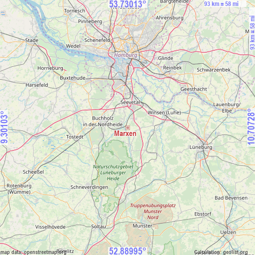
Marxen GPS coordinates[2]
53° 18' 43.596" North, 10° 0' 14.94" East
| Map corner | latitude | longitude |
|---|---|---|
| Upper-left | 53.73013°, | 9.30103° |
| Center: | 53.31211°, | 10.00415° |
| Lower-right: | 52.88995°, | 10.70728° |
| Map W x H: | 93.4×93.4 km | = 58×58mi |
| max Lat: | 55.01917° ⇑16.2% North |
| Marxen: | 53.31211° |
| min Lat: | ⇓83.8% South 47.40724° |
| min Long | Marxen | max Long |
| 5.92978° | 10.00415° | 14.98853° |
| W 50.1%⇐ | ⇒49.9% E |
Elevation
Elevation of Marxen is 28 m = 92 ft, and this is 221.1 m = 725 ft below average elevation for this country.
| Max E: |
1256 m = 4121 ft | 87.7% |
| Avg. | 249.1 m = 817 ft | |
| Marxen | 28 m = 92 ft | |
Min E: |
-5 m = -16 ft | 12.3% |
See also: Germany elevation on elevation.city.
Geographical zone
Marxen is located in North temperate zone (between Tropic of Cancer and the Arctic Circle). Distance of this North polar circle is 1473.4 km =915.5 mi to North.| Distance of | km | miles | from Marxen |
|---|---|---|---|
| North Pole | 4079.3 | 2534.8 | to North |
| Arctic Circle | 1473.4 | 915.5 | to North |
| Tropic Cancer | 3321.8 | 2064.1 | to South |
| Equator | 5927.8 | 3683.4 | to South |


Nearby cities:
15 places around Marxen: (largest is in red/bold)
• Asendorf
2.7 km =1.7 mi,  217°
217°
• Bendestorf
3.9 km =2.4 mi,  312°
312°
• Brackel
3.3 km =2.1 mi,  114°
114°
• Buchholz in der Nordheide
9.2 km =5.7 mi,  279°
279°
• Garlstorf
10.5 km =6.5 mi,  142°
142°
• Garstedt
10.9 km =6.8 mi, 106°
• Gödenstorf
12.2 km =7.6 mi, 139°
• Hanstedt
5.1 km =3.2 mi,  170°
170°
• Harmstorf
4.4 km =2.7 mi,  341°
341°
• Jesteburg
3.4 km =2.1 mi,  265°
265°
• Seevetal
10.1 km =6.3 mi,  345°
345°
• Stelle
10.7 km =6.6 mi,  41°
41°
• Toppenstedt
9.1 km =5.7 mi,  125°
125°
• Undeloh
12.9 km =8 mi,  188°
188°
• Wulfsen
9.8 km =6.1 mi,  97°
97°
Sources, notices
• [Note1] Compared only with cities in Germany existing in our database
• [Src1] Map data: © OpenStreetMap contributors (CC-BY-SA)
• [Src2] Other city data from geonames.org with taken over terms of usage.
• [Src3] Geographical zone / Annual Mean Temperature by Robert A. Rohde @ Wikipedia
