Egestorf geodata
Egestorf (Lower Saxony) is a seat of a fourth-order administrative division; located in Germany in Europe/Berlin (GMT+2) time zone. With population of 2,451 people, there are 4501 cities with bigger population in this country. Compared to other cities in Germany, 82.8% of cities are located further ↓South; 51% of cities are located further ←West and 68% of cities have higher elevation than Egestorf. Note1


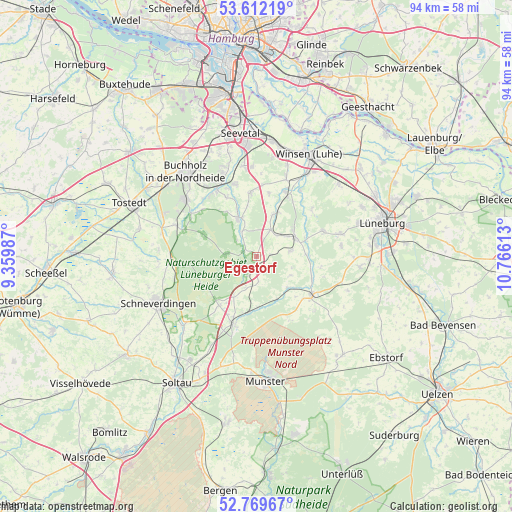
Egestorf GPS coordinates[2]
53° 11' 34.8" North, 10° 3' 46.8" East
| Map corner | latitude | longitude |
|---|---|---|
| Upper-left | 53.61219°, | 9.35987° |
| Center: | 53.193°, | 10.063° |
| Lower-right: | 52.76967°, | 10.76613° |
| Map W x H: | 93.7×93.7 km | = 58.2×58.2mi |
| max Lat: | 55.01917° ⇑17.2% North |
| Egestorf: | 53.193° |
| min Lat: | ⇓82.8% South 47.40724° |
| min Long | Egestorf | max Long |
| 5.92978° | 10.063° | 14.98853° |
| W 51%⇐ | ⇒49% E |
Elevation
Elevation of Egestorf is 102 m = 335 ft, and this is 147.1 m = 483 ft below average elevation for this country.
| Max E: |
1256 m = 4121 ft | 68% |
| Avg. | 249.1 m = 817 ft | |
| Egestorf | 102 m = 335 ft | |
Min E: |
-5 m = -16 ft | 32% |
See also: Germany elevation on elevation.city.
Geographical zone
Egestorf is located in North temperate zone (between Tropic of Cancer and the Arctic Circle). Distance of this North polar circle is 1486.7 km =923.8 mi to North.| Distance of | km | miles | from Egestorf |
|---|---|---|---|
| North Pole | 4092.6 | 2543 | to North |
| Arctic Circle | 1486.7 | 923.8 | to North |
| Tropic Cancer | 3308.6 | 2055.9 | to South |
| Equator | 5914.5 | 3675.1 | to South |


Nearby cities:
15 places around Egestorf: (largest is in red/bold)
• Amelinghausen
12.6 km =7.8 mi,  127°
127°
• Asendorf
12.4 km =7.7 mi,  333°
333°
• Bispingen
13 km =8.1 mi,  199°
199°
• Brackel
11.9 km =7.4 mi,  355°
355°
• Eyendorf
5.8 km =3.6 mi,  82°
82°
• Garlstorf
5.5 km =3.4 mi,  27°
27°
• Garstedt
12.1 km =7.5 mi, 32°
• Gödenstorf
5.6 km =3.5 mi,  45°
45°
• Hanstedt
8.8 km =5.5 mi,  339°
339°
• Oldendorf
10.9 km =6.8 mi,  112°
112°
• Salzhausen
7.9 km =4.9 mi,  64°
64°
• Soderstorf
8 km =5 mi, 134°
• Toppenstedt
8.6 km =5.3 mi,  23°
23°
• Undeloh
5.8 km =3.6 mi,  274°
274°
• Vierhöfen
13.1 km =8.1 mi, 51°
Sources, notices
• [Note1] Compared only with cities in Germany existing in our database
• [Src1] Map data: © OpenStreetMap contributors (CC-BY-SA)
• [Src2] Other city data from geonames.org with taken over terms of usage.
• [Src3] Geographical zone / Annual Mean Temperature by Robert A. Rohde @ Wikipedia
