Ibach geodata
Ibach (Baden-Württemberg) is a seat of a fourth-order administrative division; located in Germany in Europe/Berlin (GMT+2) time zone. With population of 417 people, there are 9640 cities with bigger population in this country. Compared to other cities in Germany, 98.5% of cities are located further ↑North; 76% of cities are located further →East and 99.9% of cities have lower elevation than Ibach. Note1
Administrative division(s):
- Level 1: Baden-Württemberg
- Level 2: Freiburg Region
- Level 3: Landkreis Waldshut
- Level 4: Ibach


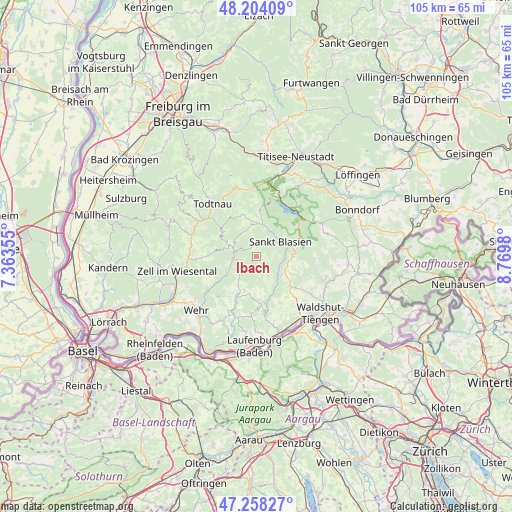
Ibach GPS coordinates[2]
47° 43' 59.988" North, 8° 4' 0.012" East
| Map corner | latitude | longitude |
|---|---|---|
| Upper-left | 48.20409°, | 7.36355° |
| Center: | 47.73333°, | 8.06667° |
| Lower-right: | 47.25827°, | 8.7698° |
| Map W x H: | 105.2×105.2 km | = 65.4×65.4mi |
| max Lat: | 55.01917° ⇑98.5% North |
| Ibach: | 47.73333° |
| min Lat: | ⇓1.5% South 47.40724° |
| min Long | Ibach | max Long |
| 5.92978° | 8.06667° | 14.98853° |
| W 24%⇐ | ⇒76% E |
Elevation
Elevation of Ibach is 937 m = 3074 ft, and this is 687.9 m = 2257 ft above average elevation for this country.
| Max E: |
1256 m = 4121 ft | 0.099999999999994% |
| Ibach | 937 m 3074 ft | |
| Avg. | 249.1 m = 817 ft | |
Min E: |
-5 m = -16 ft | 99.9% |
See also: Germany elevation on elevation.city.
Geographical zone
Ibach is located in North temperate zone (between Tropic of Cancer and the Arctic Circle). Distance of this North polar circle is 2093.7 km =1301 mi to North.| Distance of | km | miles | from Ibach |
|---|---|---|---|
| North Pole | 4699.6 | 2920.2 | to North |
| Arctic Circle | 2093.7 | 1301 | to North |
| Tropic Cancer | 2701.5 | 1678.6 | to South |
| Equator | 5307.4 | 3297.9 | to South |


Nearby cities:
15 places around Ibach: (largest is in red/bold)
• Bernau
7.7 km =4.8 mi,  344°
344°
• Dachsberg
2.5 km =1.6 mi,  99°
99°
• Görwihl
10.1 km =6.3 mi,  176°
176°
• Herrischried
8.9 km =5.5 mi,  213°
213°
• Häusern
7.7 km =4.8 mi,  76°
76°
• Höchenschwand
7.5 km =4.7 mi,  90°
90°
• Sankt Blasien
5.6 km =3.5 mi,  54°
54°
• Schluchsee
12.7 km =7.9 mi,  43°
43°
• Schönau im Schwarzwald
14.2 km =8.8 mi,  294°
294°
• Staufen
11.1 km =6.9 mi, 76°
• Todtmoos
4.9 km =3 mi,  278°
278°
• Todtnau
14.1 km =8.8 mi,  319°
319°
• Tunau
12.2 km =7.6 mi,  298°
298°
• Utzenfeld
13.4 km =8.3 mi, 303°
• Wembach
14.1 km =8.8 mi, 287°
Sources, notices
• [Note1] Compared only with cities in Germany existing in our database
• [Src1] Map data: © OpenStreetMap contributors (CC-BY-SA)
• [Src2] Other city data from geonames.org with taken over terms of usage.
• [Src3] Geographical zone / Annual Mean Temperature by Robert A. Rohde @ Wikipedia
