Titisee-Neustadt geodata
Titisee-Neustadt (Baden-Württemberg) is a populated place; located in Germany in Europe/Berlin (GMT+2) time zone. With population of 12,019 people, there are 1365 cities with bigger population in this country. Compared to other cities in Germany, 96.4% of cities are located further ↑North; 74.2% of cities are located further →East and 99.5% of cities have lower elevation than Titisee-Neustadt. Note1
Administrative division(s):
- Level 1: Baden-Württemberg
- Level 2: Freiburg Region
- Level 3: Landkreis Breisgau-Hochschwarzwald
- Level 4: Titisee-Neustadt


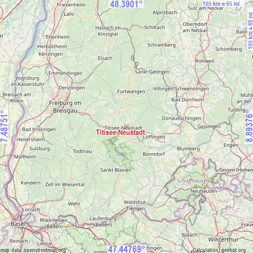
Titisee-Neustadt GPS coordinates[2]
47° 55' 15.744" North, 8° 11' 26.268" East
| Map corner | latitude | longitude |
|---|---|---|
| Upper-left | 48.3901°, | 7.48751° |
| Center: | 47.92104°, | 8.19063° |
| Lower-right: | 47.44769°, | 8.89376° |
| Map W x H: | 104.8×104.8 km | = 65.1×65.1mi |
| max Lat: | 55.01917° ⇑96.4% North |
| Titisee-Neustadt: | 47.92104° |
| min Lat: | ⇓3.6% South 47.40724° |
| min Long | Titisee-Neustad | max Long |
| 5.92978° | 8.19063° | 14.98853° |
| W 25.8%⇐ | ⇒74.2% E |
Elevation
Elevation of Titisee-Neustadt is 841 m = 2759 ft, and this is 591.9 m = 1942 ft above average elevation for this country.
| Max E: |
1256 m = 4121 ft | 0.5% |
| Titisee-Neustadt | 841 m 2759 ft | |
| Avg. | 249.1 m = 817 ft | |
Min E: |
-5 m = -16 ft | 99.5% |
See also: Germany elevation on elevation.city.
Geographical zone
Titisee-Neustadt is located in North temperate zone (between Tropic of Cancer and the Arctic Circle). Distance of this North polar circle is 2072.9 km =1288 mi to North.| Distance of | km | miles | from Titisee-Neustadt |
|---|---|---|---|
| North Pole | 4678.7 | 2907.2 | to North |
| Arctic Circle | 2072.9 | 1288 | to North |
| Tropic Cancer | 2722.4 | 1691.6 | to South |
| Equator | 5328.3 | 3310.9 | to South |


Nearby cities:
15 places around Titisee-Neustadt: (largest is in red/bold)
• Bonndorf
16 km =9.9 mi,  135°
135°
• Breitnau
8.1 km =5 mi,  279°
279°
• Buchenbach
14.2 km =8.8 mi,  288°
288°
• Eisenbach
7.3 km =4.5 mi,  52°
52°
• Friedenweiler
4.9 km =3 mi,  94°
94°
• Furtwangen
14.6 km =9.1 mi,  4°
4°
• Gütenbach
14.7 km =9.1 mi,  348°
348°
• Hinterzarten
6.6 km =4.1 mi,  251°
251°
• Lenzkirch
5.9 km =3.7 mi,  171°
171°
• Löffingen
12.1 km =7.5 mi,  109°
109°
• Reichenbach
2.8 km =1.7 mi,  70°
70°
• Sankt Märgen
12.1 km =7.5 mi,  323°
323°
• Sankt Peter
15.7 km =9.8 mi,  311°
311°
• Schluchsee
11.6 km =7.2 mi,  182°
182°
• St. Peter
15.8 km =9.8 mi, 312°
Sources, notices
• [Note1] Compared only with cities in Germany existing in our database
• [Src1] Map data: © OpenStreetMap contributors (CC-BY-SA)
• [Src2] Other city data from geonames.org with taken over terms of usage.
• [Src3] Geographical zone / Annual Mean Temperature by Robert A. Rohde @ Wikipedia
