Lenzkirch geodata
Lenzkirch (Baden-Württemberg) is a seat of a fourth-order administrative division; located in Germany in Europe/Berlin (GMT+2) time zone. With population of 5,111 people, there are 2784 cities with bigger population in this country. Compared to other cities in Germany, 96.9% of cities are located further ↑North; 74.1% of cities are located further →East and 99.3% of cities have lower elevation than Lenzkirch. Note1
Administrative division(s):
- Level 1: Baden-Württemberg
- Level 2: Freiburg Region
- Level 3: Landkreis Breisgau-Hochschwarzwald
- Level 4: Lenzkirch


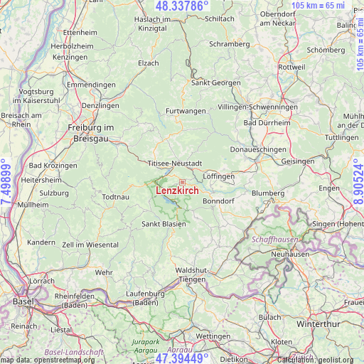
Lenzkirch GPS coordinates[2]
47° 52' 5.952" North, 8° 12' 7.596" East
| Map corner | latitude | longitude |
|---|---|---|
| Upper-left | 48.33786°, | 7.49899° |
| Center: | 47.86832°, | 8.20211° |
| Lower-right: | 47.39449°, | 8.90524° |
| Map W x H: | 104.9×104.9 km | = 65.2×65.2mi |
| max Lat: | 55.01917° ⇑96.9% North |
| Lenzkirch: | 47.86832° |
| min Lat: | ⇓3.1% South 47.40724° |
| min Long | Lenzkirch | max Long |
| 5.92978° | 8.20211° | 14.98853° |
| W 25.9%⇐ | ⇒74.1% E |
Elevation
Elevation of Lenzkirch is 810 m = 2657 ft, and this is 560.9 m = 1840 ft above average elevation for this country.
| Max E: |
1256 m = 4121 ft | 0.7% |
| Lenzkirch | 810 m 2657 ft | |
| Avg. | 249.1 m = 817 ft | |
Min E: |
-5 m = -16 ft | 99.3% |
See also: Germany elevation on elevation.city.
Geographical zone
Lenzkirch is located in North temperate zone (between Tropic of Cancer and the Arctic Circle). Distance of this North polar circle is 2078.7 km =1291.6 mi to North.| Distance of | km | miles | from Lenzkirch |
|---|---|---|---|
| North Pole | 4684.6 | 2910.9 | to North |
| Arctic Circle | 2078.7 | 1291.6 | to North |
| Tropic Cancer | 2716.5 | 1688 | to South |
| Equator | 5322.5 | 3307.2 | to South |


Nearby cities:
15 places around Lenzkirch: (largest is in red/bold)
• Bernau
14.4 km =8.9 mi,  238°
238°
• Bonndorf
11.8 km =7.3 mi,  117°
117°
• Breitnau
11.4 km =7.1 mi,  309°
309°
• Eisenbach
11.4 km =7.1 mi,  25°
25°
• Friedenweiler
6.8 km =4.2 mi,  36°
36°
• Grafenhausen
11.2 km =7 mi,  158°
158°
• Hinterzarten
8.1 km =5 mi,  298°
298°
• Häusern
13.4 km =8.3 mi,  191°
191°
• Höchenschwand
15.2 km =9.4 mi, 190°
• Löffingen
10.7 km =6.6 mi,  80°
80°
• Reichenbach
7 km =4.3 mi,  14°
14°
• Sankt Blasien
13 km =8.1 mi,  205°
205°
• Schluchsee
5.9 km =3.7 mi, 193°
• Staufen
12.4 km =7.7 mi,  177°
177°
• Titisee-Neustadt
5.9 km =3.7 mi,  351°
351°
Sources, notices
• [Note1] Compared only with cities in Germany existing in our database
• [Src1] Map data: © OpenStreetMap contributors (CC-BY-SA)
• [Src2] Other city data from geonames.org with taken over terms of usage.
• [Src3] Geographical zone / Annual Mean Temperature by Robert A. Rohde @ Wikipedia
