Reichenbach geodata
Reichenbach (Baden-Württemberg) is a populated locality; located in Germany in Europe/Berlin (GMT+2) time zone. With population of 532 people, there are 9181 cities with bigger population in this country. Compared to other cities in Germany, 96.3% of cities are located further ↑North; 73.7% of cities are located further →East and 99.7% of cities have lower elevation than Reichenbach. Note1
Administrative division(s):
- Level 1: Baden-Württemberg
- Level 2: Freiburg Region
- Level 3: Landkreis Breisgau-Hochschwarzwald
- Level 4: Titisee-Neustadt


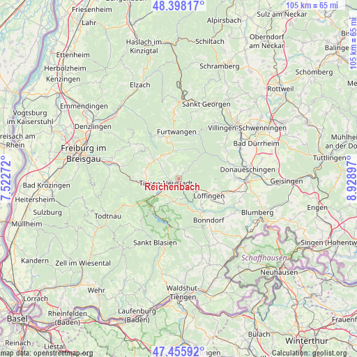
Reichenbach GPS coordinates[2]
47° 55' 45.084" North, 8° 13' 33.024" East
| Map corner | latitude | longitude |
|---|---|---|
| Upper-left | 48.39817°, | 7.52272° |
| Center: | 47.92919°, | 8.22584° |
| Lower-right: | 47.45592°, | 8.92897° |
| Map W x H: | 104.8×104.8 km | = 65.1×65.1mi |
| max Lat: | 55.01917° ⇑96.3% North |
| Reichenbach: | 47.92919° |
| min Lat: | ⇓3.7% South 47.40724° |
| min Long | Reichenbach | max Long |
| 5.92978° | 8.22584° | 14.98853° |
| W 26.3%⇐ | ⇒73.7% E |
Elevation
Elevation of Reichenbach is 881 m = 2890 ft, and this is 631.9 m = 2073 ft above average elevation for this country.
| Max E: |
1256 m = 4121 ft | 0.3% |
| Reichenbach | 881 m 2890 ft | |
| Avg. | 249.1 m = 817 ft | |
Min E: |
-5 m = -16 ft | 99.7% |
See also: Germany elevation on elevation.city.
Geographical zone
Reichenbach is located in North temperate zone (between Tropic of Cancer and the Arctic Circle). Distance of this North polar circle is 2071.9 km =1287.4 mi to North.| Distance of | km | miles | from Reichenbach |
|---|---|---|---|
| North Pole | 4677.8 | 2906.6 | to North |
| Arctic Circle | 2071.9 | 1287.4 | to North |
| Tropic Cancer | 2723.3 | 1692.2 | to South |
| Equator | 5329.2 | 3311.4 | to South |


Nearby cities:
15 places around Reichenbach: (largest is in red/bold)
• Bonndorf
15 km =9.3 mi,  144°
144°
• Breitnau
10.6 km =6.6 mi,  272°
272°
• Bräunlingen
16.6 km =10.3 mi,  89°
89°
• Buchenbach
16.5 km =10.3 mi,  282°
282°
• Eisenbach
4.7 km =2.9 mi,  41°
41°
• Friedenweiler
2.6 km =1.6 mi,  119°
119°
• Furtwangen
13.7 km =8.5 mi,  354°
354°
• Gütenbach
14.6 km =9.1 mi,  337°
337°
• Hinterzarten
9.3 km =5.8 mi,  251°
251°
• Lenzkirch
7 km =4.3 mi,  194°
194°
• Löffingen
10.1 km =6.3 mi, 119°
• Sankt Märgen
13.2 km =8.2 mi,  311°
311°
• Schluchsee
12.9 km =8 mi, 194°
• Titisee-Neustadt
2.8 km =1.7 mi, 250°
• Vöhrenbach
14.5 km =9 mi,  22°
22°
Sources, notices
• [Note1] Compared only with cities in Germany existing in our database
• [Src1] Map data: © OpenStreetMap contributors (CC-BY-SA)
• [Src2] Other city data from geonames.org with taken over terms of usage.
• [Src3] Geographical zone / Annual Mean Temperature by Robert A. Rohde @ Wikipedia
