Theuma geodata
Theuma (Saxony) is a seat of a fourth-order administrative division; located in Germany in Europe/Berlin (GMT+2) time zone. With population of 1,132 people, there are 6755 cities with bigger population in this country. Compared to other cities in Germany, 53.3% of cities are located further ↑North; 84.9% of cities are located further ←West and 87.1% of cities have lower elevation than Theuma. Note1


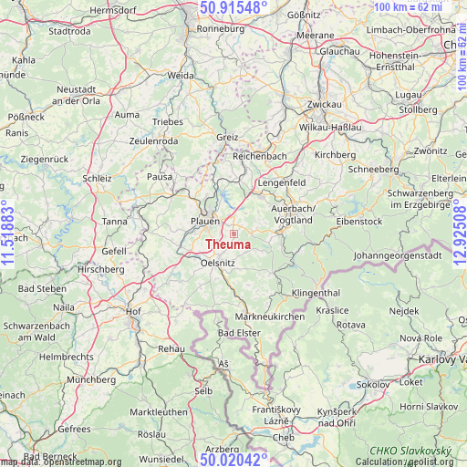
Theuma GPS coordinates[2]
50° 28' 12.252" North, 12° 13' 19.02" East
| Map corner | latitude | longitude |
|---|---|---|
| Upper-left | 50.91548°, | 11.51883° |
| Center: | 50.47007°, | 12.22195° |
| Lower-right: | 50.02042°, | 12.92508° |
| Map W x H: | 99.5×99.5 km | = 61.8×61.8mi |
| max Lat: | 55.01917° ⇑53.3% North |
| Theuma: | 50.47007° |
| min Lat: | ⇓46.7% South 47.40724° |
| min Long | Theuma | max Long |
| 5.92978° | 12.22195° | 14.98853° |
| W 84.9%⇐ | ⇒15.1% E |
Elevation
Elevation of Theuma is 486 m = 1594 ft, and this is 236.9 m = 777 ft above average elevation for this country.
| Max E: |
1256 m = 4121 ft | 12.9% |
| Theuma | 486 m 1594 ft | |
| Avg. | 249.1 m = 817 ft | |
Min E: |
-5 m = -16 ft | 87.1% |
See also: Germany elevation on elevation.city.
Geographical zone
Theuma is located in North temperate zone (between Tropic of Cancer and the Arctic Circle). Distance of this North polar circle is 1789.4 km =1111.9 mi to North.| Distance of | km | miles | from Theuma |
|---|---|---|---|
| North Pole | 4395.3 | 2731.1 | to North |
| Arctic Circle | 1789.4 | 1111.9 | to North |
| Tropic Cancer | 3005.8 | 1867.7 | to South |
| Equator | 5611.7 | 3486.9 | to South |


Nearby cities:
15 places around Theuma: (largest is in red/bold)
• Bergen
3.7 km =2.3 mi,  88°
88°
• Ellefeld
11.9 km =7.4 mi,  82°
82°
• Falkenstein
10.6 km =6.6 mi, 85°
• Grünbach
10.2 km =6.3 mi,  102°
102°
• Neuensalz
3.3 km =2.1 mi,  353°
353°
• Neustadt Vogtland
7.9 km =4.9 mi, 97°
• Oelsnitz
7.2 km =4.5 mi,  211°
211°
• Plauen
6.7 km =4.2 mi,  296°
296°
• Pöhl
9.3 km =5.8 mi,  342°
342°
• Pöhl
11.4 km =7.1 mi,  138°
138°
• Schöneck
11.6 km =7.2 mi, 139°
• Tirpersdorf
4.5 km =2.8 mi,  154°
154°
• Treuen
9.9 km =6.2 mi,  35°
35°
• Weischlitz
11.2 km =7 mi,  258°
258°
• Werda
6.9 km =4.3 mi,  121°
121°
Sources, notices
• [Note1] Compared only with cities in Germany existing in our database
• [Src1] Map data: © OpenStreetMap contributors (CC-BY-SA)
• [Src2] Other city data from geonames.org with taken over terms of usage.
• [Src3] Geographical zone / Annual Mean Temperature by Robert A. Rohde @ Wikipedia
