Werda geodata
Werda (Saxony) is a seat of a fourth-order administrative division; located in Germany in Europe/Berlin (GMT+2) time zone. With population of 1,774 people, there are 5390 cities with bigger population in this country. Compared to other cities in Germany, 53.9% of cities are located further ↑North; 85.9% of cities are located further ←West and 95.8% of cities have lower elevation than Werda. Note1


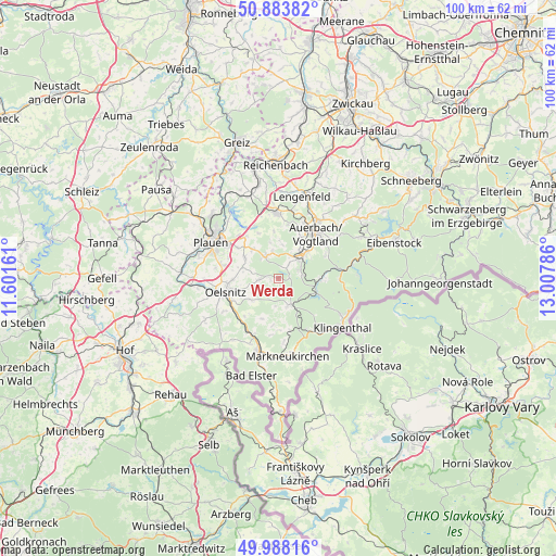
Werda GPS coordinates[2]
50° 26' 17.196" North, 12° 18' 17.028" East
| Map corner | latitude | longitude |
|---|---|---|
| Upper-left | 50.88382°, | 11.60161° |
| Center: | 50.43811°, | 12.30473° |
| Lower-right: | 49.98816°, | 13.00786° |
| Map W x H: | 99.6×99.6 km | = 61.9×61.9mi |
| max Lat: | 55.01917° ⇑53.9% North |
| Werda: | 50.43811° |
| min Lat: | ⇓46.1% South 47.40724° |
| min Long | Werda | max Long |
| 5.92978° | 12.30473° | 14.98853° |
| W 85.9%⇐ | ⇒14.1% E |
Elevation
Elevation of Werda is 619 m = 2031 ft, and this is 369.9 m = 1214 ft above average elevation for this country.
| Max E: |
1256 m = 4121 ft | 4.2% |
| Werda | 619 m 2031 ft | |
| Avg. | 249.1 m = 817 ft | |
Min E: |
-5 m = -16 ft | 95.8% |
See also: Germany elevation on elevation.city.
Geographical zone
Werda is located in North temperate zone (between Tropic of Cancer and the Arctic Circle). Distance of this North polar circle is 1793 km =1114.1 mi to North.| Distance of | km | miles | from Werda |
|---|---|---|---|
| North Pole | 4398.9 | 2733.3 | to North |
| Arctic Circle | 1793 | 1114.1 | to North |
| Tropic Cancer | 3002.3 | 1865.5 | to South |
| Equator | 5608.2 | 3484.8 | to South |


Nearby cities:
15 places around Werda: (largest is in red/bold)
• Auerbach
10.6 km =6.6 mi,  39°
39°
• Bergen
4.2 km =2.6 mi,  329°
329°
• Ellefeld
7.8 km =4.8 mi,  49°
49°
• Falkenstein
6.5 km =4 mi, 46°
• Grünbach
4.3 km =2.7 mi,  71°
71°
• Hammerbrücke
7.8 km =4.8 mi,  92°
92°
• Neuensalz
9.3 km =5.8 mi,  317°
317°
• Neustadt Vogtland
3.2 km =2 mi, 37°
• Oelsnitz
9.9 km =6.2 mi,  254°
254°
• Pöhl
5.3 km =3.3 mi,  160°
160°
• Schöneck
5.5 km =3.4 mi, 163°
• Tannenbergsthal
10.8 km =6.7 mi, 90°
• Theuma
6.9 km =4.3 mi,  301°
301°
• Tirpersdorf
3.9 km =2.4 mi,  262°
262°
• Treuen
11.6 km =7.2 mi,  359°
359°
Sources, notices
• [Note1] Compared only with cities in Germany existing in our database
• [Src1] Map data: © OpenStreetMap contributors (CC-BY-SA)
• [Src2] Other city data from geonames.org with taken over terms of usage.
• [Src3] Geographical zone / Annual Mean Temperature by Robert A. Rohde @ Wikipedia
