Schöneck geodata
Schöneck (Saxony) is a populated place; located in Germany in Europe/Berlin (GMT+2) time zone. With population of 3,728 people, there are 3455 cities with bigger population in this country. Compared to other cities in Germany, 54.8% of cities are located further ↑North; 86% of cities are located further ←West and 97.9% of cities have lower elevation than Schöneck. Note1


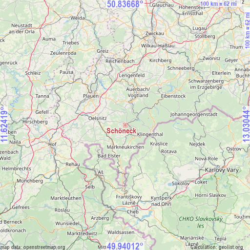
Schöneck GPS coordinates[2]
50° 23' 25.872" North, 12° 19' 38.316" East
| Map corner | latitude | longitude |
|---|---|---|
| Upper-left | 50.83668°, | 11.62419° |
| Center: | 50.39052°, | 12.32731° |
| Lower-right: | 49.94012°, | 13.03044° |
| Map W x H: | 99.7×99.7 km | = 62×62mi |
| max Lat: | 55.01917° ⇑54.8% North |
| Schöneck: | 50.39052° |
| min Lat: | ⇓45.2% South 47.40724° |
| min Long | Schöneck | max Long |
| 5.92978° | 12.32731° | 14.98853° |
| W 86%⇐ | ⇒14% E |
Elevation
Elevation of Schöneck is 701 m = 2300 ft, and this is 451.9 m = 1483 ft above average elevation for this country.
| Max E: |
1256 m = 4121 ft | 2.1% |
| Schöneck | 701 m 2300 ft | |
| Avg. | 249.1 m = 817 ft | |
Min E: |
-5 m = -16 ft | 97.9% |
See also: Germany elevation on elevation.city.
Geographical zone
Schöneck is located in North temperate zone (between Tropic of Cancer and the Arctic Circle). Distance of this North polar circle is 1798.3 km =1117.4 mi to North.| Distance of | km | miles | from Schöneck |
|---|---|---|---|
| North Pole | 4404.2 | 2736.6 | to North |
| Arctic Circle | 1798.3 | 1117.4 | to North |
| Tropic Cancer | 2997 | 1862.2 | to South |
| Equator | 5602.9 | 3481.5 | to South |


Nearby cities:
15 places around Schöneck: (largest is in red/bold)
• Adorf
9.2 km =5.7 mi,  211°
211°
• Bergen
9.7 km =6 mi,  337°
337°
• Ellefeld
11.2 km =7 mi,  22°
22°
• Erlbach
8.7 km =5.4 mi,  161°
161°
• Falkenstein
10.2 km =6.3 mi, 17°
• Grünbach
7 km =4.3 mi, 20°
• Hammerbrücke
7.9 km =4.9 mi,  51°
51°
• Klingenthal
10.3 km =6.4 mi,  109°
109°
• Markneukirchen
8.8 km =5.5 mi,  178°
178°
• Neustadt Vogtland
7.8 km =4.8 mi,  2°
2°
• Pöhl
0.3 km =0.2 mi, 23°
• Tannenbergsthal
10.6 km =6.6 mi,  60°
60°
• Tirpersdorf
7.3 km =4.5 mi,  310°
310°
• Werda
5.5 km =3.4 mi, 343°
• Zwota
8 km =5 mi,  123°
123°
Sources, notices
• [Note1] Compared only with cities in Germany existing in our database
• [Src1] Map data: © OpenStreetMap contributors (CC-BY-SA)
• [Src2] Other city data from geonames.org with taken over terms of usage.
• [Src3] Geographical zone / Annual Mean Temperature by Robert A. Rohde @ Wikipedia
