Tauer geodata
Tauer (Brandenburg) is a seat of a fourth-order administrative division; located in Germany in Europe/Berlin (GMT+2) time zone. With population of 785 people, there are 7961 cities with bigger population in this country. Compared to other cities in Germany, 71.1% of cities are located further ↓South; 99.2% of cities are located further ←West and 74.1% of cities have higher elevation than Tauer. Note1


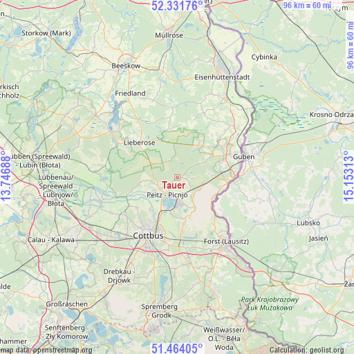
Tauer GPS coordinates[2]
51° 54' 0" North, 14° 27' 0" East
| Map corner | latitude | longitude |
|---|---|---|
| Upper-left | 52.33176°, | 13.74688° |
| Center: | 51.9°, | 14.45° |
| Lower-right: | 51.46405°, | 15.15313° |
| Map W x H: | 96.5×96.5 km | = 60×60mi |
| max Lat: | 55.01917° ⇑28.9% North |
| Tauer: | 51.9° |
| min Lat: | ⇓71.1% South 47.40724° |
| min Long | Tauer | max Long |
| 5.92978° | 14.45° | 14.98853° |
| W 99.2%⇐ | ⇒0.8% E |
Elevation
Elevation of Tauer is 67 m = 220 ft, and this is 182.1 m = 597 ft below average elevation for this country.
| Max E: |
1256 m = 4121 ft | 74.1% |
| Avg. | 249.1 m = 817 ft | |
| Tauer | 67 m = 220 ft | |
Min E: |
-5 m = -16 ft | 25.9% |
See also: Germany elevation on elevation.city.
Geographical zone
Tauer is located in North temperate zone (between Tropic of Cancer and the Arctic Circle). Distance of this North polar circle is 1630.4 km =1013.1 mi to North.| Distance of | km | miles | from Tauer |
|---|---|---|---|
| North Pole | 4236.3 | 2632.3 | to North |
| Arctic Circle | 1630.4 | 1013.1 | to North |
| Tropic Cancer | 3164.8 | 1966.5 | to South |
| Equator | 5770.7 | 3585.7 | to South |


Nearby cities:
15 places around Tauer: (largest is in red/bold)
• Briesen
17 km =10.6 mi,  236°
236°
• Burg
21.9 km =13.6 mi,  250°
250°
• Cottbus
17.9 km =11.1 mi,  207°
207°
• Drachhausen
9.2 km =5.7 mi,  263°
263°
• Drehnow
6.8 km =4.2 mi, 237°
• Guben
19 km =11.8 mi,  72°
72°
• Guhrow
18 km =11.2 mi, 237°
• Heinersbrück
9.7 km =6 mi,  156°
156°
• Jamlitz
11.8 km =7.3 mi,  329°
329°
• Jänschwalde
5.5 km =3.4 mi,  142°
142°
• Kolkwitz
21.6 km =13.4 mi,  219°
219°
• Lieberose
14 km =8.7 mi,  312°
312°
• Peitz
5.3 km =3.3 mi, 209°
• Schenkendöbern
14.2 km =8.8 mi,  63°
63°
• Werben
20.5 km =12.7 mi, 243°
Sources, notices
• [Note1] Compared only with cities in Germany existing in our database
• [Src1] Map data: © OpenStreetMap contributors (CC-BY-SA)
• [Src2] Other city data from geonames.org with taken over terms of usage.
• [Src3] Geographical zone / Annual Mean Temperature by Robert A. Rohde @ Wikipedia
