Guben geodata
Guben (Brandenburg) is a populated place; located in Germany in Europe/Berlin (GMT+2) time zone. With population of 21,608 people, there are 698 cities with bigger population in this country. Compared to other cities in Germany, 71.6% of cities are located further ↓South; 99.8% of cities are located further ←West and 79.9% of cities have higher elevation than Guben. Note1


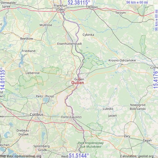
Guben GPS coordinates[2]
51° 56' 59.532" North, 14° 42' 52.092" East
| Map corner | latitude | longitude |
|---|---|---|
| Upper-left | 52.38115°, | 14.01135° |
| Center: | 51.94987°, | 14.71447° |
| Lower-right: | 51.5144°, | 15.4176° |
| Map W x H: | 96.4×96.4 km | = 59.9×59.9mi |
| max Lat: | 55.01917° ⇑28.4% North |
| Guben: | 51.94987° |
| min Lat: | ⇓71.6% South 47.40724° |
| min Long | Guben | max Long |
| 5.92978° | 14.71447° | 14.98853° |
| W 99.8%⇐ | ⇒0.2% E |
Elevation
Elevation of Guben is 47 m = 154 ft, and this is 202.1 m = 663 ft below average elevation for this country.
| Max E: |
1256 m = 4121 ft | 79.9% |
| Avg. | 249.1 m = 817 ft | |
| Guben | 47 m = 154 ft | |
Min E: |
-5 m = -16 ft | 20.1% |
See also: Germany elevation on elevation.city.
Geographical zone
Guben is located in North temperate zone (between Tropic of Cancer and the Arctic Circle). Distance of this North polar circle is 1624.9 km =1009.7 mi to North.| Distance of | km | miles | from Guben |
|---|---|---|---|
| North Pole | 4230.8 | 2628.9 | to North |
| Arctic Circle | 1624.9 | 1009.7 | to North |
| Tropic Cancer | 3170.4 | 1970 | to South |
| Equator | 5776.3 | 3589.2 | to South |


Nearby cities:
15 places around Guben: (largest is in red/bold)
• Drachhausen
28.1 km =17.5 mi,  256°
256°
• Drehnow
25.6 km =15.9 mi,  248°
248°
• Eisenhüttenstadt
22.7 km =14.1 mi,  348°
348°
• Forst
24.4 km =15.2 mi,  192°
192°
• Heinersbrück
20.3 km =12.6 mi,  224°
224°
• Jamlitz
24.6 km =15.3 mi,  280°
280°
• Jänschwalde
17.9 km =11.1 mi,  236°
236°
• Lawitz
18.2 km =11.3 mi,  344°
344°
• Lieberose
28.7 km =17.8 mi, 277°
• Neuzelle
16.2 km =10.1 mi, 343°
• Peitz
23.1 km =14.4 mi, 243°
• Schenkendöbern
5.5 km =3.4 mi, 278°
• Tauer
19 km =11.8 mi, 252°
• Vogelsang
26.1 km =16.2 mi, 352°
• Ziltendorf
29.1 km =18.1 mi, 347°
Sources, notices
• [Note1] Compared only with cities in Germany existing in our database
• [Src1] Map data: © OpenStreetMap contributors (CC-BY-SA)
• [Src2] Other city data from geonames.org with taken over terms of usage.
• [Src3] Geographical zone / Annual Mean Temperature by Robert A. Rohde @ Wikipedia
