Tarthun geodata
Tarthun (Saxony-Anhalt) is a populated place; located in Germany in Europe/Berlin (GMT+2) time zone. With population of 837 people, there are 7750 cities with bigger population in this country. Compared to other cities in Germany, 71.4% of cities are located further ↓South; 73.9% of cities are located further ←West and 73.4% of cities have higher elevation than Tarthun. Note1


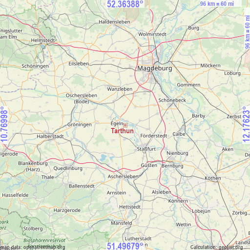
Tarthun GPS coordinates[2]
51° 55' 56.748" North, 11° 28' 23.16" East
| Map corner | latitude | longitude |
|---|---|---|
| Upper-left | 52.36388°, | 10.76998° |
| Center: | 51.93243°, | 11.4731° |
| Lower-right: | 51.49679°, | 12.17623° |
| Map W x H: | 96.4×96.4 km | = 59.9×59.9mi |
| max Lat: | 55.01917° ⇑28.6% North |
| Tarthun: | 51.93243° |
| min Lat: | ⇓71.4% South 47.40724° |
| min Long | Tarthun | max Long |
| 5.92978° | 11.4731° | 14.98853° |
| W 73.9%⇐ | ⇒26.1% E |
Elevation
Elevation of Tarthun is 70 m = 230 ft, and this is 179.1 m = 588 ft below average elevation for this country.
| Max E: |
1256 m = 4121 ft | 73.4% |
| Avg. | 249.1 m = 817 ft | |
| Tarthun | 70 m = 230 ft | |
Min E: |
-5 m = -16 ft | 26.6% |
See also: Germany elevation on elevation.city.
Geographical zone
Tarthun is located in North temperate zone (between Tropic of Cancer and the Arctic Circle). Distance of this North polar circle is 1626.8 km =1010.8 mi to North.| Distance of | km | miles | from Tarthun |
|---|---|---|---|
| North Pole | 4232.7 | 2630.1 | to North |
| Arctic Circle | 1626.8 | 1010.8 | to North |
| Tropic Cancer | 3168.4 | 1968.8 | to South |
| Equator | 5774.3 | 3588 | to South |


Nearby cities:
15 places around Tarthun: (largest is in red/bold)
• Atzendorf
8.8 km =5.5 mi,  99°
99°
• Borne
6.1 km =3.8 mi,  72°
72°
• Bottmersdorf
11.3 km =7 mi,  344°
344°
• Cochstedt
7 km =4.3 mi,  217°
217°
• Egeln
3 km =1.9 mi,  294°
294°
• Etgersleben
6.6 km =4.1 mi,  321°
321°
• Förderstedt
11.7 km =7.3 mi,  109°
109°
• Groß Börnecke
5.3 km =3.3 mi,  182°
182°
• Hakeborn
7.6 km =4.7 mi,  258°
258°
• Hecklingen
10.4 km =6.5 mi,  156°
156°
• Kroppenstedt
11.3 km =7 mi,  275°
275°
• Schneidlingen
4.6 km =2.9 mi,  204°
204°
• Unseburg
2.7 km =1.7 mi,  89°
89°
• Westeregeln
6.5 km =4 mi,  301°
301°
• Wolmirsleben
2.1 km =1.3 mi,  19°
19°
Sources, notices
• [Note1] Compared only with cities in Germany existing in our database
• [Src1] Map data: © OpenStreetMap contributors (CC-BY-SA)
• [Src2] Other city data from geonames.org with taken over terms of usage.
• [Src3] Geographical zone / Annual Mean Temperature by Robert A. Rohde @ Wikipedia
