Atzendorf geodata
Atzendorf (Saxony-Anhalt) is a populated place; located in Germany in Europe/Berlin (GMT+2) time zone. With population of 1,586 people, there are 5706 cities with bigger population in this country. Compared to other cities in Germany, 71.3% of cities are located further ↓South; 75.7% of cities are located further ←West and 71.1% of cities have higher elevation than Atzendorf. Note1


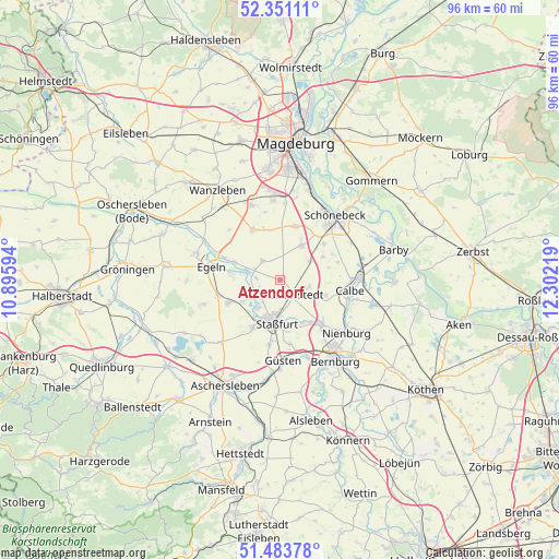
Atzendorf GPS coordinates[2]
51° 55' 10.344" North, 11° 35' 56.616" East
| Map corner | latitude | longitude |
|---|---|---|
| Upper-left | 52.35111°, | 10.89594° |
| Center: | 51.91954°, | 11.59906° |
| Lower-right: | 51.48378°, | 12.30219° |
| Map W x H: | 96.4×96.4 km | = 59.9×59.9mi |
| max Lat: | 55.01917° ⇑28.7% North |
| Atzendorf: | 51.91954° |
| min Lat: | ⇓71.3% South 47.40724° |
| min Long | Atzendorf | max Long |
| 5.92978° | 11.59906° | 14.98853° |
| W 75.7%⇐ | ⇒24.3% E |
Elevation
Elevation of Atzendorf is 84 m = 276 ft, and this is 165.1 m = 542 ft below average elevation for this country.
| Max E: |
1256 m = 4121 ft | 71.1% |
| Avg. | 249.1 m = 817 ft | |
| Atzendorf | 84 m = 276 ft | |
Min E: |
-5 m = -16 ft | 28.9% |
See also: Germany elevation on elevation.city.
Geographical zone
Atzendorf is located in North temperate zone (between Tropic of Cancer and the Arctic Circle). Distance of this North polar circle is 1628.3 km =1011.8 mi to North.| Distance of | km | miles | from Atzendorf |
|---|---|---|---|
| North Pole | 4234.2 | 2631 | to North |
| Arctic Circle | 1628.3 | 1011.8 | to North |
| Tropic Cancer | 3167 | 1967.9 | to South |
| Equator | 5772.9 | 3587.1 | to South |


Nearby cities:
15 places around Atzendorf: (largest is in red/bold)
• Biere
7.2 km =4.5 mi,  31°
31°
• Borne
4.3 km =2.7 mi,  319°
319°
• Brumby
8.5 km =5.3 mi,  107°
107°
• Eggersdorf
9.9 km =6.2 mi,  50°
50°
• Eickendorf
6.1 km =3.8 mi,  59°
59°
• Förderstedt
3.4 km =2.1 mi,  136°
136°
• Glöthe
5.3 km =3.3 mi,  101°
101°
• Groß Börnecke
9.6 km =6 mi,  246°
246°
• Hecklingen
9.2 km =5.7 mi,  208°
208°
• Klein Mühlingen
10.5 km =6.5 mi,  72°
72°
• Staßfurt
7.6 km =4.7 mi,  187°
187°
• Tarthun
8.8 km =5.5 mi,  279°
279°
• Unseburg
6.1 km =3.8 mi, 284°
• Welsleben
9.7 km =6 mi,  16°
16°
• Wolmirsleben
8.6 km =5.3 mi,  293°
293°
Sources, notices
• [Note1] Compared only with cities in Germany existing in our database
• [Src1] Map data: © OpenStreetMap contributors (CC-BY-SA)
• [Src2] Other city data from geonames.org with taken over terms of usage.
• [Src3] Geographical zone / Annual Mean Temperature by Robert A. Rohde @ Wikipedia
