Tann geodata
Tann (Hesse) is a populated place; located in Germany in Europe/Berlin (GMT+2) time zone. With population of 4,695 people, there are 2940 cities with bigger population in this country. Compared to other cities in Germany, 50.6% of cities are located further ↓South; 50.5% of cities are located further ←West and 73.3% of cities have lower elevation than Tann. Note1
Administrative division(s):
- Level 1: Hesse
- Level 2: Regierungsbezirk Kassel
- Level 3: Landkreis Fulda
- Level 4: Tann (Rhön)


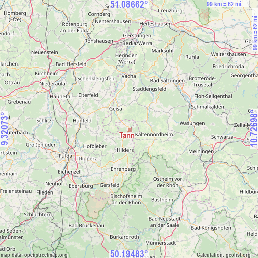
Tann GPS coordinates[2]
50° 38' 34.224" North, 10° 1' 25.86" East
| Map corner | latitude | longitude |
|---|---|---|
| Upper-left | 51.08662°, | 9.32073° |
| Center: | 50.64284°, | 10.02385° |
| Lower-right: | 50.19483°, | 10.72698° |
| Map W x H: | 99.2×99.2 km | = 61.6×61.6mi |
| max Lat: | 55.01917° ⇑49.4% North |
| Tann: | 50.64284° |
| min Lat: | ⇓50.6% South 47.40724° |
| min Long | Tann | max Long |
| 5.92978° | 10.02385° | 14.98853° |
| W 50.5%⇐ | ⇒49.5% E |
Elevation
Elevation of Tann is 385 m = 1263 ft, and this is 135.9 m = 446 ft above average elevation for this country.
| Max E: |
1256 m = 4121 ft | 26.7% |
| Tann | 385 m 1263 ft | |
| Avg. | 249.1 m = 817 ft | |
Min E: |
-5 m = -16 ft | 73.3% |
See also: Germany elevation on elevation.city.
Geographical zone
Tann is located in North temperate zone (between Tropic of Cancer and the Arctic Circle). Distance of this North polar circle is 1770.2 km =1100 mi to North.| Distance of | km | miles | from Tann |
|---|---|---|---|
| North Pole | 4376.1 | 2719.2 | to North |
| Arctic Circle | 1770.2 | 1100 | to North |
| Tropic Cancer | 3025 | 1879.6 | to South |
| Equator | 5631 | 3498.9 | to South |


Nearby cities:
15 places around Tann: (largest is in red/bold)
• Andenhausen
4 km =2.5 mi,  48°
48°
• Dermbach
10.3 km =6.4 mi,  40°
40°
• Empfertshausen
6 km =3.7 mi,  63°
63°
• Frankenheim
11.4 km =7.1 mi,  163°
163°
• Geisa
9.5 km =5.9 mi,  327°
327°
• Hilders
8 km =5 mi,  190°
190°
• Kaltennordheim
9.7 km =6 mi,  100°
100°
• Kaltensundheim
10.2 km =6.3 mi,  113°
113°
• Kaltenwestheim
7.5 km =4.7 mi,  119°
119°
• Klings
6.6 km =4.1 mi,  83°
83°
• Neidhartshausen
8.9 km =5.5 mi, 59°
• Oberweid
6.5 km =4 mi,  154°
154°
• Oechsen
11.7 km =7.3 mi,  13°
13°
• Schleid
7.5 km =4.7 mi, 327°
• Unterweid
4.5 km =2.8 mi,  144°
144°
Sources, notices
• [Note1] Compared only with cities in Germany existing in our database
• [Src1] Map data: © OpenStreetMap contributors (CC-BY-SA)
• [Src2] Other city data from geonames.org with taken over terms of usage.
• [Src3] Geographical zone / Annual Mean Temperature by Robert A. Rohde @ Wikipedia
