Oechsen geodata
Oechsen (Thuringia) is a seat of a fourth-order administrative division; located in Germany in Europe/Berlin (GMT+2) time zone. With population of 685 people, there are 8387 cities with bigger population in this country. Compared to other cities in Germany, 53.2% of cities are located further ↓South; 51% of cities are located further ←West and 74.9% of cities have lower elevation than Oechsen. Note1


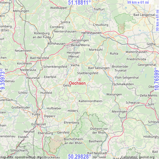
Oechsen GPS coordinates[2]
50° 44' 43.116" North, 10° 3' 46.296" East
| Map corner | latitude | longitude |
|---|---|---|
| Upper-left | 51.18811°, | 9.35973° |
| Center: | 50.74531°, | 10.06286° |
| Lower-right: | 50.29828°, | 10.76599° |
| Map W x H: | 98.9×98.9 km | = 61.5×61.5mi |
| max Lat: | 55.01917° ⇑46.8% North |
| Oechsen: | 50.74531° |
| min Lat: | ⇓53.2% South 47.40724° |
| min Long | Oechsen | max Long |
| 5.92978° | 10.06286° | 14.98853° |
| W 51%⇐ | ⇒49% E |
Elevation
Elevation of Oechsen is 397 m = 1302 ft, and this is 147.9 m = 485 ft above average elevation for this country.
| Max E: |
1256 m = 4121 ft | 25.1% |
| Oechsen | 397 m 1302 ft | |
| Avg. | 249.1 m = 817 ft | |
Min E: |
-5 m = -16 ft | 74.9% |
See also: Germany elevation on elevation.city.
Geographical zone
Oechsen is located in North temperate zone (between Tropic of Cancer and the Arctic Circle). Distance of this North polar circle is 1758.8 km =1092.9 mi to North.| Distance of | km | miles | from Oechsen |
|---|---|---|---|
| North Pole | 4364.7 | 2712.1 | to North |
| Arctic Circle | 1758.8 | 1092.9 | to North |
| Tropic Cancer | 3036.4 | 1886.7 | to South |
| Equator | 5642.3 | 3506 | to South |


Nearby cities:
15 places around Oechsen: (largest is in red/bold)
• Andenhausen
8.7 km =5.4 mi,  178°
178°
• Buttlar
7.9 km =4.9 mi,  280°
280°
• Dermbach
5.2 km =3.2 mi,  131°
131°
• Empfertshausen
9.1 km =5.7 mi,  163°
163°
• Geisa
8.6 km =5.3 mi,  246°
246°
• Martinroda
6.1 km =3.8 mi,  2°
2°
• Neidhartshausen
8.5 km =5.3 mi,  144°
144°
• Schleid
8.4 km =5.2 mi,  233°
233°
• Stadtlengsfeld
6.3 km =3.9 mi,  47°
47°
• Urnshausen
7.9 km =4.9 mi,  98°
98°
• Vacha
9.6 km =6 mi,  342°
342°
• Völkershausen
6.1 km =3.8 mi,  351°
351°
• Weilar
6.6 km =4.1 mi,  68°
68°
• Wiesenthal
8.9 km =5.5 mi,  124°
124°
• Wölferbütt
2.5 km =1.6 mi, 339°
Sources, notices
• [Note1] Compared only with cities in Germany existing in our database
• [Src1] Map data: © OpenStreetMap contributors (CC-BY-SA)
• [Src2] Other city data from geonames.org with taken over terms of usage.
• [Src3] Geographical zone / Annual Mean Temperature by Robert A. Rohde @ Wikipedia
