Heilbronn geodata
Heilbronn (Baden-Württemberg) is a seat of a third-order administrative division; located in Germany in Europe/Berlin (GMT+2) time zone. With population of 120,733 people, there are 72 cities with bigger population in this country. Compared to other cities in Germany, 81.3% of cities are located further ↑North; 62% of cities are located further →East and 57.2% of cities have higher elevation than Heilbronn. Note1
Administrative division(s):
- Level 1: Baden-Württemberg
- Level 2: Regierungsbezirk Stuttgart
- Level 3: Stadtkreis Heilbronn
- Level 4: Heilbronn


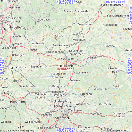
Heilbronn GPS coordinates[2]
49° 8' 23.82" North, 9° 13' 13.944" East
| Map corner | latitude | longitude |
|---|---|---|
| Upper-left | 49.59781°, | 8.51742° |
| Center: | 49.13995°, | 9.22054° |
| Lower-right: | 48.67782°, | 9.92367° |
| Map W x H: | 102.3×102.3 km | = 63.6×63.6mi |
| max Lat: | 55.01917° ⇑81.3% North |
| Heilbronn: | 49.13995° |
| min Lat: | ⇓18.7% South 47.40724° |
| min Long | Heilbronn | max Long |
| 5.92978° | 9.22054° | 14.98853° |
| W 38%⇐ | ⇒62% E |
Elevation
Elevation of Heilbronn is 173 m = 568 ft, and this is 76.1 m = 250 ft below average elevation for this country.
| Max E: |
1256 m = 4121 ft | 57.2% |
| Avg. | 249.1 m = 817 ft | |
| Heilbronn | 173 m = 568 ft | |
Min E: |
-5 m = -16 ft | 42.8% |
See also: Heilbronn elevation on elevation.city.
Geographical zone
Heilbronn is located in North temperate zone (between Tropic of Cancer and the Arctic Circle). Distance of this North polar circle is 1937.3 km =1203.8 mi to North.| Distance of | km | miles | from Heilbronn |
|---|---|---|---|
| North Pole | 4543.2 | 2823 | to North |
| Arctic Circle | 1937.3 | 1203.8 | to North |
| Tropic Cancer | 2857.9 | 1775.8 | to South |
| Equator | 5463.9 | 3395.1 | to South |


Nearby cities:
15 places around Heilbronn: (largest is in red/bold)
• Abstatt
9.5 km =5.9 mi,  147°
147°
• Eberstadt
8.6 km =5.3 mi,  58°
58°
• Ellhofen
7.4 km =4.6 mi,  84°
84°
• Erlenbach
5 km =3.1 mi,  43°
43°
• Flein
4.2 km =2.6 mi,  189°
189°
• Ilsfeld
9.6 km =6 mi,  168°
168°
• Lauffen am Neckar
9.2 km =5.7 mi,  216°
216°
• Lehrensteinsfeld
7.8 km =4.8 mi,  97°
97°
• Leingarten
7.6 km =4.7 mi,  275°
275°
• Neckarsulm
5.5 km =3.4 mi,  3°
3°
• Nordheim
7.6 km =4.7 mi,  242°
242°
• Talheim
6.6 km =4.1 mi,  197°
197°
• Untereisesheim
8 km =5 mi,  350°
350°
• Untergruppenbach
6.9 km =4.3 mi,  144°
144°
• Weinsberg
5 km =3.1 mi, 75°
Sources, notices
• [Note1] Compared only with cities in Germany existing in our database
• [Src1] Map data: © OpenStreetMap contributors (CC-BY-SA)
• [Src2] Other city data from geonames.org with taken over terms of usage.
• [Src3] Geographical zone / Annual Mean Temperature by Robert A. Rohde @ Wikipedia
