Süstedt geodata
Süstedt (Lower Saxony) is a seat of a fourth-order administrative division; located in Germany in Europe/Berlin (GMT+2) time zone. With population of 1,533 people, there are 5816 cities with bigger population in this country. Compared to other cities in Germany, 80.8% of cities are located further ↓South; 66.4% of cities are located further →East and 90.5% of cities have higher elevation than Süstedt. Note1
Administrative division(s):
- Level 1: Lower Saxony
- Level 3: Landkreis Diepholz
- Level 4: Bruchhausen-Vilsen, Flecken


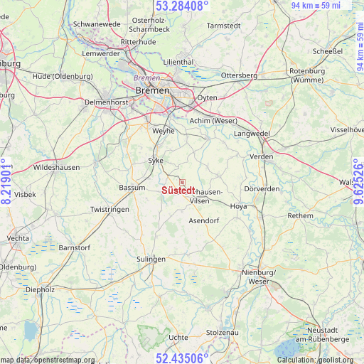
Süstedt GPS coordinates[2]
52° 51' 41.94" North, 8° 55' 19.668" East
| Map corner | latitude | longitude |
|---|---|---|
| Upper-left | 53.28408°, | 8.21901° |
| Center: | 52.86165°, | 8.92213° |
| Lower-right: | 52.43506°, | 9.62526° |
| Map W x H: | 94.4×94.4 km | = 58.7×58.7mi |
| max Lat: | 55.01917° ⇑19.2% North |
| Süstedt: | 52.86165° |
| min Lat: | ⇓80.8% South 47.40724° |
| min Long | Süstedt | max Long |
| 5.92978° | 8.92213° | 14.98853° |
| W 33.6%⇐ | ⇒66.4% E |
Elevation
Elevation of Süstedt is 20 m = 66 ft, and this is 229.1 m = 752 ft below average elevation for this country.
| Max E: |
1256 m = 4121 ft | 90.5% |
| Avg. | 249.1 m = 817 ft | |
| Süstedt | 20 m = 66 ft | |
Min E: |
-5 m = -16 ft | 9.5% |
See also: Germany elevation on elevation.city.
Geographical zone
Süstedt is located in North temperate zone (between Tropic of Cancer and the Arctic Circle). Distance of this North polar circle is 1523.5 km =946.7 mi to North.| Distance of | km | miles | from Süstedt |
|---|---|---|---|
| North Pole | 4129.4 | 2565.9 | to North |
| Arctic Circle | 1523.5 | 946.7 | to North |
| Tropic Cancer | 3271.7 | 2032.9 | to South |
| Equator | 5877.7 | 3652.2 | to South |


Nearby cities:
15 places around Süstedt: (largest is in red/bold)
• Affinghausen
9.1 km =5.7 mi,  196°
196°
• Asendorf
11.4 km =7.1 mi,  150°
150°
• Bassum
13.1 km =8.1 mi,  264°
264°
• Bruchhausen-Vilsen
5.8 km =3.6 mi,  128°
128°
• Emtinghausen
8.5 km =5.3 mi,  20°
20°
• Engeln
7.6 km =4.7 mi,  182°
182°
• Hoyerhagen
11.3 km =7 mi,  106°
106°
• Martfeld
9.4 km =5.8 mi,  80°
80°
• Morsum
14.7 km =9.1 mi,  45°
45°
• Neuenkirchen
14.9 km =9.3 mi,  230°
230°
• Riede
11.8 km =7.3 mi,  9°
9°
• Schwarme
7.6 km =4.7 mi,  56°
56°
• Sudwalde
9.5 km =5.9 mi,  217°
217°
• Syke
8.8 km =5.5 mi,  310°
310°
• Thedinghausen
13.3 km =8.3 mi,  28°
28°
Sources, notices
• [Note1] Compared only with cities in Germany existing in our database
• [Src1] Map data: © OpenStreetMap contributors (CC-BY-SA)
• [Src2] Other city data from geonames.org with taken over terms of usage.
• [Src3] Geographical zone / Annual Mean Temperature by Robert A. Rohde @ Wikipedia
