Asendorf geodata
Asendorf (Lower Saxony) is a seat of a fourth-order administrative division; located in Germany in Europe/Berlin (GMT+2) time zone. With population of 3,108 people, there are 3910 cities with bigger population in this country. Compared to other cities in Germany, 80.2% of cities are located further ↓South; 65.4% of cities are located further →East and 77.9% of cities have higher elevation than Asendorf. Note1


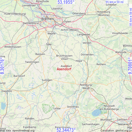
Asendorf GPS coordinates[2]
52° 46' 19.884" North, 9° 0' 17.604" East
| Map corner | latitude | longitude |
|---|---|---|
| Upper-left | 53.1955°, | 8.30176° |
| Center: | 52.77219°, | 9.00489° |
| Lower-right: | 52.34473°, | 9.70801° |
| Map W x H: | 94.6×94.6 km | = 58.8×58.8mi |
| max Lat: | 55.01917° ⇑19.8% North |
| Asendorf: | 52.77219° |
| min Lat: | ⇓80.2% South 47.40724° |
| min Long | Asendorf | max Long |
| 5.92978° | 9.00489° | 14.98853° |
| W 34.6%⇐ | ⇒65.4% E |
Elevation
Elevation of Asendorf is 53 m = 174 ft, and this is 196.1 m = 643 ft below average elevation for this country.
| Max E: |
1256 m = 4121 ft | 77.9% |
| Avg. | 249.1 m = 817 ft | |
| Asendorf | 53 m = 174 ft | |
Min E: |
-5 m = -16 ft | 22.1% |
See also: Germany elevation on elevation.city.
Geographical zone
Asendorf is located in North temperate zone (between Tropic of Cancer and the Arctic Circle). Distance of this North polar circle is 1533.5 km =952.9 mi to North.| Distance of | km | miles | from Asendorf |
|---|---|---|---|
| North Pole | 4139.3 | 2572 | to North |
| Arctic Circle | 1533.5 | 952.9 | to North |
| Tropic Cancer | 3261.8 | 2026.8 | to South |
| Equator | 5867.7 | 3646 | to South |


Nearby cities:
15 places around Asendorf: (largest is in red/bold)
• Affinghausen
8.3 km =5.2 mi,  278°
278°
• Borstel
11.6 km =7.2 mi,  192°
192°
• Bruchhausen-Vilsen
6.4 km =4 mi,  351°
351°
• Bücken
8.7 km =5.4 mi,  85°
85°
• Engeln
6.3 km =3.9 mi,  292°
292°
• Hoya
9.9 km =6.2 mi,  66°
66°
• Hoyerhagen
8.6 km =5.3 mi,  37°
37°
• Maasen
12 km =7.5 mi,  222°
222°
• Mellinghausen
10.3 km =6.4 mi,  225°
225°
• Siedenburg
9.8 km =6.1 mi,  206°
206°
• Staffhorst
6.7 km =4.2 mi,  202°
202°
• Sudwalde
11.6 km =7.2 mi, 281°
• Süstedt
11.4 km =7.1 mi,  330°
330°
• Warpe
7.7 km =4.8 mi,  124°
124°
• Wietzen
8.1 km =5 mi,  139°
139°
Sources, notices
• [Note1] Compared only with cities in Germany existing in our database
• [Src1] Map data: © OpenStreetMap contributors (CC-BY-SA)
• [Src2] Other city data from geonames.org with taken over terms of usage.
• [Src3] Geographical zone / Annual Mean Temperature by Robert A. Rohde @ Wikipedia
