Süpplingenburg geodata
Süpplingenburg (Lower Saxony) is a seat of a fourth-order administrative division; located in Germany in Europe/Berlin (GMT+2) time zone. With population of 722 people, there are 8225 cities with bigger population in this country. Compared to other cities in Germany, 74.7% of cities are located further ↓South; 65.6% of cities are located further ←West and 66% of cities have higher elevation than Süpplingenburg. Note1
Administrative division(s):
- Level 1: Lower Saxony
- Level 3: Landkreis Helmstedt
- Level 4: Süpplingenburg


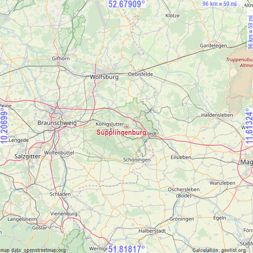
Süpplingenburg GPS coordinates[2]
52° 15' 2.592" North, 10° 54' 36.396" East
| Map corner | latitude | longitude |
|---|---|---|
| Upper-left | 52.67909°, | 10.20699° |
| Center: | 52.25072°, | 10.91011° |
| Lower-right: | 51.81817°, | 11.61324° |
| Map W x H: | 95.7×95.7 km | = 59.5×59.5mi |
| max Lat: | 55.01917° ⇑25.3% North |
| Süpplingenburg: | 52.25072° |
| min Lat: | ⇓74.7% South 47.40724° |
| min Long | Süpplingenburg | max Long |
| 5.92978° | 10.91011° | 14.98853° |
| W 65.6%⇐ | ⇒34.4% E |
Elevation
Elevation of Süpplingenburg is 114 m = 374 ft, and this is 135.1 m = 443 ft below average elevation for this country.
| Max E: |
1256 m = 4121 ft | 66% |
| Avg. | 249.1 m = 817 ft | |
| Süpplingenburg | 114 m = 374 ft | |
Min E: |
-5 m = -16 ft | 34% |
See also: Germany elevation on elevation.city.
Geographical zone
Süpplingenburg is located in North temperate zone (between Tropic of Cancer and the Arctic Circle). Distance of this North polar circle is 1591.4 km =988.8 mi to North.| Distance of | km | miles | from Süpplingenburg |
|---|---|---|---|
| North Pole | 4197.3 | 2608.1 | to North |
| Arctic Circle | 1591.4 | 988.8 | to North |
| Tropic Cancer | 3203.8 | 1990.7 | to South |
| Equator | 5809.7 | 3610 | to South |


Nearby cities:
15 places around Süpplingenburg: (largest is in red/bold)
• Büddenstedt
11.6 km =7.2 mi,  140°
140°
• Frellstedt
5 km =3.1 mi,  175°
175°
• Grasleben
9.4 km =5.8 mi,  48°
48°
• Harbke
11.6 km =7.2 mi,  126°
126°
• Helmstedt
7.2 km =4.5 mi,  110°
110°
• Königslutter am Elm
6.3 km =3.9 mi,  270°
270°
• Mariental
5.7 km =3.5 mi,  60°
60°
• Querenhorst
10 km =6.2 mi,  22°
22°
• Rennau
5 km =3.1 mi,  1°
1°
• Räbke
6.4 km =4 mi,  199°
199°
• Süpplingen
2.5 km =1.6 mi,  189°
189°
• Walbeck
11 km =6.8 mi,  73°
73°
• Warberg
7.8 km =4.8 mi, 175°
• Weferlingen
12.1 km =7.5 mi, 55°
• Wolsdorf
6.9 km =4.3 mi,  163°
163°
Sources, notices
• [Note1] Compared only with cities in Germany existing in our database
• [Src1] Map data: © OpenStreetMap contributors (CC-BY-SA)
• [Src2] Other city data from geonames.org with taken over terms of usage.
• [Src3] Geographical zone / Annual Mean Temperature by Robert A. Rohde @ Wikipedia
