Süpplingen geodata
Süpplingen (Lower Saxony) is a seat of a fourth-order administrative division; located in Germany in Europe/Berlin (GMT+2) time zone. With population of 1,857 people, there are 5262 cities with bigger population in this country. Compared to other cities in Germany, 74.4% of cities are located further ↓South; 65.6% of cities are located further ←West and 66.5% of cities have higher elevation than Süpplingen. Note1


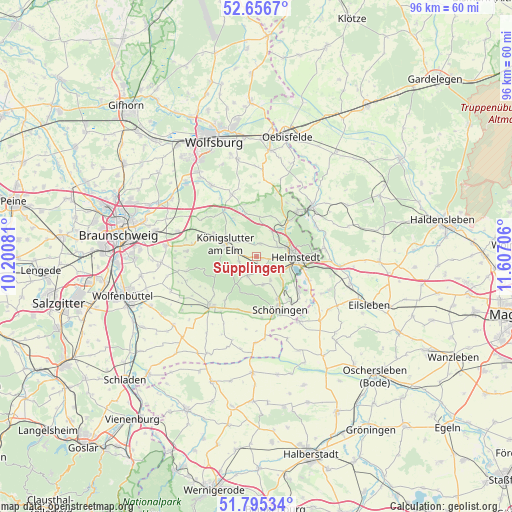
Süpplingen GPS coordinates[2]
52° 13' 41.196" North, 10° 54' 14.148" East
| Map corner | latitude | longitude |
|---|---|---|
| Upper-left | 52.6567°, | 10.20081° |
| Center: | 52.22811°, | 10.90393° |
| Lower-right: | 51.79534°, | 11.60706° |
| Map W x H: | 95.8×95.8 km | = 59.5×59.5mi |
| max Lat: | 55.01917° ⇑25.6% North |
| Süpplingen: | 52.22811° |
| min Lat: | ⇓74.4% South 47.40724° |
| min Long | Süpplingen | max Long |
| 5.92978° | 10.90393° | 14.98853° |
| W 65.6%⇐ | ⇒34.4% E |
Elevation
Elevation of Süpplingen is 111 m = 364 ft, and this is 138.1 m = 453 ft below average elevation for this country.
| Max E: |
1256 m = 4121 ft | 66.5% |
| Avg. | 249.1 m = 817 ft | |
| Süpplingen | 111 m = 364 ft | |
Min E: |
-5 m = -16 ft | 33.5% |
See also: Germany elevation on elevation.city.
Geographical zone
Süpplingen is located in North temperate zone (between Tropic of Cancer and the Arctic Circle). Distance of this North polar circle is 1594 km =990.5 mi to North.| Distance of | km | miles | from Süpplingen |
|---|---|---|---|
| North Pole | 4199.8 | 2609.6 | to North |
| Arctic Circle | 1594 | 990.5 | to North |
| Tropic Cancer | 3201.3 | 1989.2 | to South |
| Equator | 5807.2 | 3608.4 | to South |


Nearby cities:
15 places around Süpplingen: (largest is in red/bold)
• Büddenstedt
10.1 km =6.3 mi,  129°
129°
• Dahlum
11.2 km =7 mi,  199°
199°
• Frellstedt
2.6 km =1.6 mi,  162°
162°
• Grasleben
11.5 km =7.1 mi,  40°
40°
• Harbke
10.6 km =6.6 mi,  114°
114°
• Helmstedt
7.2 km =4.5 mi,  90°
90°
• Kneitlingen
11.3 km =7 mi,  238°
238°
• Königslutter am Elm
6.5 km =4 mi,  293°
293°
• Mariental
7.6 km =4.7 mi,  45°
45°
• Rennau
7.6 km =4.7 mi,  4°
4°
• Räbke
4 km =2.5 mi,  205°
205°
• Schöningen
10.9 km =6.8 mi, 156°
• Süpplingenburg
2.5 km =1.6 mi,  9°
9°
• Warberg
5.3 km =3.3 mi,  168°
168°
• Wolsdorf
4.8 km =3 mi,  150°
150°
Sources, notices
• [Note1] Compared only with cities in Germany existing in our database
• [Src1] Map data: © OpenStreetMap contributors (CC-BY-SA)
• [Src2] Other city data from geonames.org with taken over terms of usage.
• [Src3] Geographical zone / Annual Mean Temperature by Robert A. Rohde @ Wikipedia
