Königslutter am Elm geodata
Königslutter am Elm (Lower Saxony) is a populated place; located in Germany in Europe/Berlin (GMT+2) time zone. With population of 16,419 people, there are 964 cities with bigger population in this country. Compared to other cities in Germany, 74.7% of cities are located further ↓South; 64.4% of cities are located further ←West and 62.3% of cities have higher elevation than Königslutter am Elm. Note1
Administrative division(s):
- Level 1: Lower Saxony
- Level 3: Landkreis Helmstedt
- Level 4: Königslutter am Elm


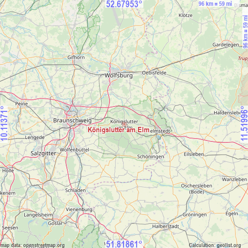
Königslutter am Elm GPS coordinates[2]
52° 15' 4.176" North, 10° 49' 0.588" East
| Map corner | latitude | longitude |
|---|---|---|
| Upper-left | 52.67953°, | 10.11371° |
| Center: | 52.25116°, | 10.81683° |
| Lower-right: | 51.81861°, | 11.51996° |
| Map W x H: | 95.7×95.7 km | = 59.5×59.5mi |
| max Lat: | 55.01917° ⇑25.3% North |
| Königslutter am Elm: | 52.25116° |
| min Lat: | ⇓74.7% South 47.40724° |
| min Long | Königslutter a | max Long |
| 5.92978° | 10.81683° | 14.98853° |
| W 64.4%⇐ | ⇒35.6% E |
Elevation
Elevation of Königslutter am Elm is 136 m = 446 ft, and this is 113.1 m = 371 ft below average elevation for this country.
| Max E: |
1256 m = 4121 ft | 62.3% |
| Avg. | 249.1 m = 817 ft | |
| Königslutter am Elm | 136 m = 446 ft | |
Min E: |
-5 m = -16 ft | 37.7% |
See also: Germany elevation on elevation.city.
Geographical zone
Königslutter am Elm is located in North temperate zone (between Tropic of Cancer and the Arctic Circle). Distance of this North polar circle is 1591.4 km =988.8 mi to North.| Distance of | km | miles | from Königslutter am Elm |
|---|---|---|---|
| North Pole | 4197.3 | 2608.1 | to North |
| Arctic Circle | 1591.4 | 988.8 | to North |
| Tropic Cancer | 3203.9 | 1990.8 | to South |
| Equator | 5809.8 | 3610 | to South |


Nearby cities:
15 places around Königslutter am Elm: (largest is in red/bold)
• Cremlingen
11.4 km =7.1 mi,  269°
269°
• Destedt
7.4 km =4.6 mi,  258°
258°
• Erkerode
8.9 km =5.5 mi,  234°
234°
• Evessen
10 km =6.2 mi, 226°
• Frellstedt
8.4 km =5.2 mi,  126°
126°
• Kneitlingen
9.3 km =5.8 mi,  203°
203°
• Mariental
11.7 km =7.3 mi,  76°
76°
• Rennau
8.2 km =5.1 mi,  52°
52°
• Räbke
7.4 km =4.6 mi,  145°
145°
• Schöppenstedt
12.4 km =7.7 mi,  193°
193°
• Süpplingen
6.5 km =4 mi,  113°
113°
• Süpplingenburg
6.3 km =3.9 mi,  90°
90°
• Veltheim
9.8 km =6.1 mi,  248°
248°
• Warberg
10.5 km =6.5 mi,  137°
137°
• Wolsdorf
10.7 km =6.6 mi, 128°
Sources, notices
• [Note1] Compared only with cities in Germany existing in our database
• [Src1] Map data: © OpenStreetMap contributors (CC-BY-SA)
• [Src2] Other city data from geonames.org with taken over terms of usage.
• [Src3] Geographical zone / Annual Mean Temperature by Robert A. Rohde @ Wikipedia
