Sulingen geodata
Sulingen (Lower Saxony) is a populated place; located in Germany in Europe/Berlin (GMT+2) time zone. With population of 12,835 people, there are 1259 cities with bigger population in this country. Compared to other cities in Germany, 79.5% of cities are located further ↓South; 67.8% of cities are located further →East and 77.3% of cities have higher elevation than Sulingen. Note1


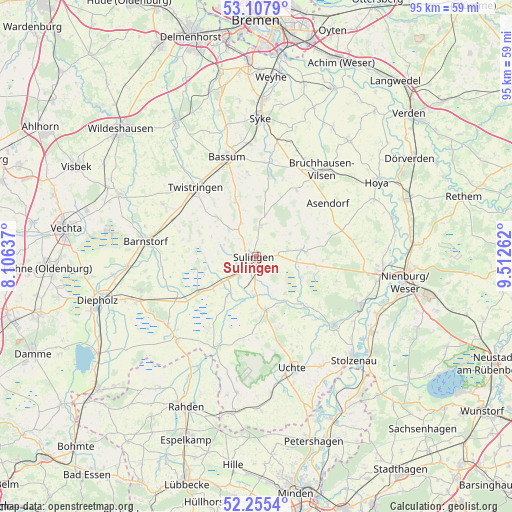
Sulingen GPS coordinates[2]
52° 41' 1.428" North, 8° 48' 34.164" East
| Map corner | latitude | longitude |
|---|---|---|
| Upper-left | 53.1079°, | 8.10637° |
| Center: | 52.68373°, | 8.80949° |
| Lower-right: | 52.2554°, | 9.51262° |
| Map W x H: | 94.8×94.8 km | = 58.9×58.9mi |
| max Lat: | 55.01917° ⇑20.5% North |
| Sulingen: | 52.68373° |
| min Lat: | ⇓79.5% South 47.40724° |
| min Long | Sulingen | max Long |
| 5.92978° | 8.80949° | 14.98853° |
| W 32.2%⇐ | ⇒67.8% E |
Elevation
Elevation of Sulingen is 55 m = 180 ft, and this is 194.1 m = 637 ft below average elevation for this country.
| Max E: |
1256 m = 4121 ft | 77.3% |
| Avg. | 249.1 m = 817 ft | |
| Sulingen | 55 m = 180 ft | |
Min E: |
-5 m = -16 ft | 22.7% |
See also: Germany elevation on elevation.city.
Geographical zone
Sulingen is located in North temperate zone (between Tropic of Cancer and the Arctic Circle). Distance of this North polar circle is 1543.3 km =959 mi to North.| Distance of | km | miles | from Sulingen |
|---|---|---|---|
| North Pole | 4149.2 | 2578.2 | to North |
| Arctic Circle | 1543.3 | 959 | to North |
| Tropic Cancer | 3252 | 2020.7 | to South |
| Equator | 5857.9 | 3639.9 | to South |


Nearby cities:
15 places around Sulingen: (largest is in red/bold)
• Affinghausen
12.1 km =7.5 mi,  24°
24°
• Barenburg
7.2 km =4.5 mi,  185°
185°
• Borstel
10.9 km =6.8 mi,  97°
97°
• Ehrenburg
10.4 km =6.5 mi,  314°
314°
• Hassel
2.1 km =1.3 mi,  46°
46°
• Kirchdorf
10 km =6.2 mi,  170°
170°
• Maasen
5.1 km =3.2 mi,  79°
79°
• Mellinghausen
6.4 km =4 mi,  66°
66°
• Neuenkirchen
11 km =6.8 mi,  338°
338°
• Scholen
6.2 km =3.9 mi,  332°
332°
• Schwaförden
6.2 km =3.9 mi,  13°
13°
• Siedenburg
8.8 km =5.5 mi, 83°
• Staffhorst
11.2 km =7 mi, 70°
• Varrel
8.6 km =5.3 mi,  216°
216°
• Wehrbleck
10.1 km =6.3 mi,  232°
232°
Sources, notices
• [Note1] Compared only with cities in Germany existing in our database
• [Src1] Map data: © OpenStreetMap contributors (CC-BY-SA)
• [Src2] Other city data from geonames.org with taken over terms of usage.
• [Src3] Geographical zone / Annual Mean Temperature by Robert A. Rohde @ Wikipedia
