Maasen geodata
Maasen (Lower Saxony) is a seat of a fourth-order administrative division; located in Germany in Europe/Berlin (GMT+2) time zone. With population of 544 people, there are 9118 cities with bigger population in this country. Compared to other cities in Germany, 79.6% of cities are located further ↓South; 66.9% of cities are located further →East and 79.4% of cities have higher elevation than Maasen. Note1


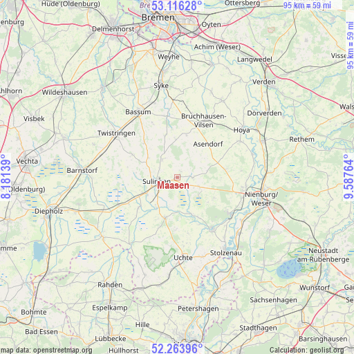
Maasen GPS coordinates[2]
52° 41' 31.92" North, 8° 53' 4.236" East
| Map corner | latitude | longitude |
|---|---|---|
| Upper-left | 53.11628°, | 8.18139° |
| Center: | 52.6922°, | 8.88451° |
| Lower-right: | 52.26396°, | 9.58764° |
| Map W x H: | 94.8×94.8 km | = 58.9×58.9mi |
| max Lat: | 55.01917° ⇑20.4% North |
| Maasen: | 52.6922° |
| min Lat: | ⇓79.6% South 47.40724° |
| min Long | Maasen | max Long |
| 5.92978° | 8.88451° | 14.98853° |
| W 33.1%⇐ | ⇒66.9% E |
Elevation
Elevation of Maasen is 48 m = 157 ft, and this is 201.1 m = 660 ft below average elevation for this country.
| Max E: |
1256 m = 4121 ft | 79.4% |
| Avg. | 249.1 m = 817 ft | |
| Maasen | 48 m = 157 ft | |
Min E: |
-5 m = -16 ft | 20.6% |
See also: Germany elevation on elevation.city.
Geographical zone
Maasen is located in North temperate zone (between Tropic of Cancer and the Arctic Circle). Distance of this North polar circle is 1542.4 km =958.4 mi to North.| Distance of | km | miles | from Maasen |
|---|---|---|---|
| North Pole | 4148.2 | 2577.6 | to North |
| Arctic Circle | 1542.4 | 958.4 | to North |
| Tropic Cancer | 3252.9 | 2021.3 | to South |
| Equator | 5858.8 | 3640.5 | to South |


Nearby cities:
15 places around Maasen: (largest is in red/bold)
• Affinghausen
10.1 km =6.3 mi,  359°
359°
• Asendorf
12 km =7.5 mi,  42°
42°
• Barenburg
9.9 km =6.2 mi,  215°
215°
• Borstel
6.2 km =3.9 mi,  113°
113°
• Engeln
11.5 km =7.1 mi,  11°
11°
• Hassel
3.6 km =2.2 mi,  278°
278°
• Kirchdorf
11.3 km =7 mi,  197°
197°
• Mellinghausen
1.8 km =1.1 mi,  27°
27°
• Pennigsehl
11.1 km =6.9 mi,  120°
120°
• Scholen
9.2 km =5.7 mi,  299°
299°
• Schwaförden
6.2 km =3.9 mi,  324°
324°
• Siedenburg
3.7 km =2.3 mi,  88°
88°
• Staffhorst
6.2 km =3.9 mi,  63°
63°
• Sudwalde
11.7 km =7.3 mi,  343°
343°
• Sulingen
5.1 km =3.2 mi,  259°
259°
Sources, notices
• [Note1] Compared only with cities in Germany existing in our database
• [Src1] Map data: © OpenStreetMap contributors (CC-BY-SA)
• [Src2] Other city data from geonames.org with taken over terms of usage.
• [Src3] Geographical zone / Annual Mean Temperature by Robert A. Rohde @ Wikipedia
