Ehrenburg geodata
Ehrenburg (Lower Saxony) is a seat of a fourth-order administrative division; located in Germany in Europe/Berlin (GMT+2) time zone. With population of 1,686 people, there are 5537 cities with bigger population in this country. Compared to other cities in Germany, 80% of cities are located further ↓South; 69.1% of cities are located further →East and 81% of cities have higher elevation than Ehrenburg. Note1


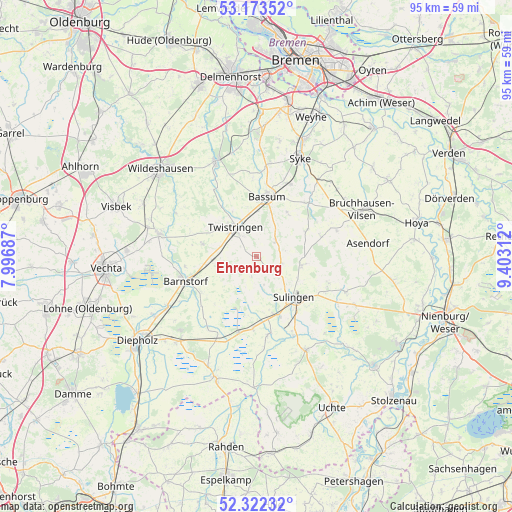
Ehrenburg GPS coordinates[2]
52° 45' 0" North, 8° 42' 0" East
| Map corner | latitude | longitude |
|---|---|---|
| Upper-left | 53.17352°, | 7.99687° |
| Center: | 52.75°, | 8.7° |
| Lower-right: | 52.32232°, | 9.40312° |
| Map W x H: | 94.6×94.6 km | = 58.8×58.8mi |
| max Lat: | 55.01917° ⇑20% North |
| Ehrenburg: | 52.75° |
| min Lat: | ⇓80% South 47.40724° |
| min Long | Ehrenburg | max Long |
| 5.92978° | 8.7° | 14.98853° |
| W 30.9%⇐ | ⇒69.1% E |
Elevation
Elevation of Ehrenburg is 44 m = 144 ft, and this is 205.1 m = 673 ft below average elevation for this country.
| Max E: |
1256 m = 4121 ft | 81% |
| Avg. | 249.1 m = 817 ft | |
| Ehrenburg | 44 m = 144 ft | |
Min E: |
-5 m = -16 ft | 19% |
See also: Germany elevation on elevation.city.
Geographical zone
Ehrenburg is located in North temperate zone (between Tropic of Cancer and the Arctic Circle). Distance of this North polar circle is 1535.9 km =954.4 mi to North.| Distance of | km | miles | from Ehrenburg |
|---|---|---|---|
| North Pole | 4141.8 | 2573.6 | to North |
| Arctic Circle | 1535.9 | 954.4 | to North |
| Tropic Cancer | 3259.3 | 2025.2 | to South |
| Equator | 5865.3 | 3644.5 | to South |


Nearby cities:
15 places around Ehrenburg: (largest is in red/bold)
• Affinghausen
12.9 km =8 mi,  73°
73°
• Barnstorf
14 km =8.7 mi,  251°
251°
• Bassum
11.3 km =7 mi,  9°
9°
• Drentwede
9.1 km =5.7 mi,  265°
265°
• Eydelstedt
12.1 km =7.5 mi,  238°
238°
• Hassel
10.7 km =6.6 mi,  123°
123°
• Maasen
14 km =8.7 mi, 117°
• Mellinghausen
14.1 km =8.8 mi,  109°
109°
• Neuenkirchen
4.5 km =2.8 mi,  49°
49°
• Scholen
4.9 km =3 mi, 112°
• Schwaförden
8.9 km =5.5 mi,  98°
98°
• Sudwalde
10.3 km =6.4 mi,  62°
62°
• Sulingen
10.4 km =6.5 mi,  134°
134°
• Twistringen
6.7 km =4.2 mi,  324°
324°
• Wehrbleck
13.5 km =8.4 mi,  182°
182°
Sources, notices
• [Note1] Compared only with cities in Germany existing in our database
• [Src1] Map data: © OpenStreetMap contributors (CC-BY-SA)
• [Src2] Other city data from geonames.org with taken over terms of usage.
• [Src3] Geographical zone / Annual Mean Temperature by Robert A. Rohde @ Wikipedia
