Suhl geodata
Suhl (Thuringia) is a seat of a third-order administrative division; located in Germany in Europe/Berlin (GMT+2) time zone. With population of 43,509 people, there are 281 cities with bigger population in this country. Compared to other cities in Germany, 50.3% of cities are located further ↑North; 62.4% of cities are located further ←West and 81.3% of cities have lower elevation than Suhl. Note1


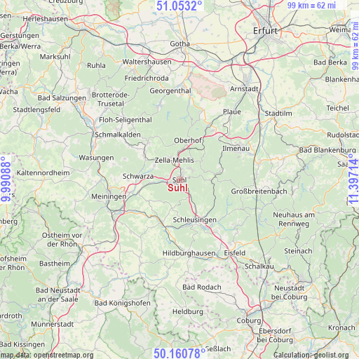
Suhl GPS coordinates[2]
50° 36' 32.796" North, 10° 41' 38.436" East
| Map corner | latitude | longitude |
|---|---|---|
| Upper-left | 51.0532°, | 9.99088° |
| Center: | 50.60911°, | 10.69401° |
| Lower-right: | 50.16078°, | 11.39714° |
| Map W x H: | 99.2×99.2 km | = 61.6×61.6mi |
| max Lat: | 55.01917° ⇑50.3% North |
| Suhl: | 50.60911° |
| min Lat: | ⇓49.7% South 47.40724° |
| min Long | Suhl | max Long |
| 5.92978° | 10.69401° | 14.98853° |
| W 62.4%⇐ | ⇒37.6% E |
Elevation
Elevation of Suhl is 442 m = 1450 ft, and this is 192.9 m = 633 ft above average elevation for this country.
| Max E: |
1256 m = 4121 ft | 18.7% |
| Suhl | 442 m 1450 ft | |
| Avg. | 249.1 m = 817 ft | |
Min E: |
-5 m = -16 ft | 81.3% |
See also: Suhl elevation on elevation.city.
Geographical zone
Suhl is located in North temperate zone (between Tropic of Cancer and the Arctic Circle). Distance of this North polar circle is 1774 km =1102.3 mi to North.| Distance of | km | miles | from Suhl |
|---|---|---|---|
| North Pole | 4379.9 | 2721.5 | to North |
| Arctic Circle | 1774 | 1102.3 | to North |
| Tropic Cancer | 3021.3 | 1877.3 | to South |
| Equator | 5627.2 | 3496.6 | to South |


Nearby cities:
15 places around Suhl: (largest is in red/bold)
• Ahlstädt
8.5 km =5.3 mi,  185°
185°
• Benshausen
8 km =5 mi,  304°
304°
• Bermbach
10.3 km =6.4 mi,  317°
317°
• Bischofrod
7.3 km =4.5 mi,  205°
205°
• Eichenberg
6.9 km =4.3 mi,  196°
196°
• Gehlberg
10.3 km =6.4 mi,  41°
41°
• Grub
7.8 km =4.8 mi, 213°
• Lengfeld
9 km =5.6 mi, 200°
• Marisfeld
10.4 km =6.5 mi,  235°
235°
• Oberhof
10.8 km =6.7 mi,  12°
12°
• Oberstadt
9 km =5.6 mi,  228°
228°
• Sankt Kilian
10.3 km =6.4 mi,  151°
151°
• Schmeheim
9.1 km =5.7 mi, 238°
• Schmiedefeld am Rennsteig
8.4 km =5.2 mi,  90°
90°
• Zella-Mehlis
5.8 km =3.6 mi,  335°
335°
Sources, notices
• [Note1] Compared only with cities in Germany existing in our database
• [Src1] Map data: © OpenStreetMap contributors (CC-BY-SA)
• [Src2] Other city data from geonames.org with taken over terms of usage.
• [Src3] Geographical zone / Annual Mean Temperature by Robert A. Rohde @ Wikipedia
