Schmiedefeld am Rennsteig geodata
Schmiedefeld am Rennsteig (Thuringia) is a seat of a fourth-order administrative division; located in Germany in Europe/Berlin (GMT+2) time zone. With population of 1,989 people, there are 5088 cities with bigger population in this country. Compared to other cities in Germany, 50.3% of cities are located further ↑North; 64.2% of cities are located further ←West and 97.8% of cities have lower elevation than Schmiedefeld am Rennsteig. Note1
Current local time in Schmiedefeld am Rennsteig:
05:58 PM, FridayDifference from your time zone: hours


Schmiedefeld am Rennsteig GPS coordinates[2]
50° 36' 31.068" North, 10° 48' 46.224" East
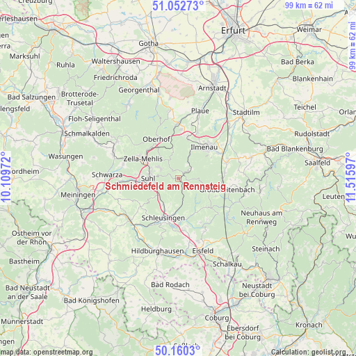
| Map corner | latitude | longitude |
|---|---|---|
| Upper-left | 51.05273°, | 10.10972° |
| Center: | 50.60863°, | 10.81284° |
| Lower-right: | 50.1603°, | 11.51597° |
| Map W x H: | 99.2×99.2 km | = 61.6×61.6mi |
| max Lat: | 55.01917° ⇑50.3% North |
| Schmiedefeld am Rennsteig: | 50.60863° |
| min Lat: | ⇓49.7% South 47.40724° |
| min Long | Schmiedefeld am | max Long |
| 5.92978° | 10.81284° | 14.98853° |
| W 64.2%⇐ | ⇒35.8% E |
Elevation
Elevation of Schmiedefeld am Rennsteig is 697 m = 2287 ft, and this is 447.9 m = 1469 ft above average elevation for this country.
| Max E: |
1256 m = 4121 ft | 2.2% |
| Schmiedefeld am Rennsteig | 697 m 2287 ft | |
| Avg. | 249.1 m = 817 ft | |
Min E: |
-5 m = -16 ft | 97.8% |
See also: Germany elevation on elevation.city.
Geographical zone
Schmiedefeld am Rennsteig is located in North temperate zone (between Tropic of Cancer and the Arctic Circle). Distance of this North polar circle is 1774 km =1102.3 mi to North.| Distance of | km | miles | from Schmiedefeld am Rennsteig |
|---|---|---|---|
| North Pole | 4379.9 | 2721.5 | to North |
| Arctic Circle | 1774 | 1102.3 | to North |
| Tropic Cancer | 3021.2 | 1877.3 | to South |
| Equator | 5627.2 | 3496.6 | to South |


Nearby cities:
15 places around Schmiedefeld am Rennsteig: (largest is in red/bold)
• Altenfeld
11.8 km =7.3 mi,  113°
113°
• Eichenberg
12.2 km =7.6 mi,  237°
237°
• Elgersburg
11.2 km =7 mi,  14°
14°
• Frauenwald
4.2 km =2.6 mi,  130°
130°
• Gehlberg
7.9 km =4.9 mi,  348°
348°
• Geraberg
12.1 km =7.5 mi, 8°
• Ilmenau
11.2 km =7 mi,  41°
41°
• Neuhaus
11.9 km =7.4 mi,  45°
45°
• Neustadt am Rennsteig
9 km =5.6 mi, 108°
• Oberhof
12.2 km =7.6 mi,  330°
330°
• Sankt Kilian
9.7 km =6 mi,  201°
201°
• Schleusingen
11.6 km =7.2 mi, 200°
• Stützerbach
4.7 km =2.9 mi, 54°
• Suhl
8.4 km =5.2 mi,  270°
270°
• Zella-Mehlis
12 km =7.5 mi,  296°
296°
Sources, notices
• [Note1] Compared only with cities in Germany existing in our database
• [Src1] Map data: © OpenStreetMap contributors (CC-BY-SA)
• [Src2] Other city data from geonames.org with taken over terms of usage.
• [Src3] Geographical zone / Annual Mean Temperature by Robert A. Rohde @ Wikipedia
