Zella-Mehlis geodata
Zella-Mehlis (Thuringia) is a populated place; located in Germany in Europe/Berlin (GMT+2) time zone. With population of 12,361 people, there are 1319 cities with bigger population in this country. Compared to other cities in Germany, 50.9% of cities are located further ↓South; 61.8% of cities are located further ←West and 86.9% of cities have lower elevation than Zella-Mehlis. Note1
Administrative division(s):
- Level 1: Thuringia
- Level 3: Landkreis Schmalkalden-Meiningen
- Level 4: Zella-Mehlis


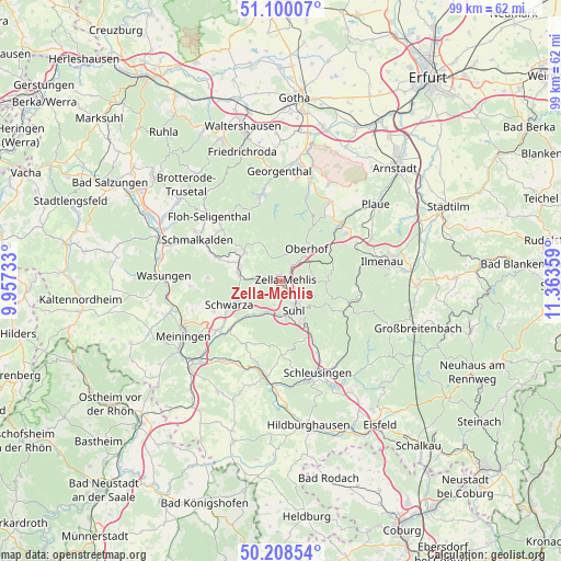
Zella-Mehlis GPS coordinates[2]
50° 39' 23.112" North, 10° 39' 37.656" East
| Map corner | latitude | longitude |
|---|---|---|
| Upper-left | 51.10007°, | 9.95733° |
| Center: | 50.65642°, | 10.66046° |
| Lower-right: | 50.20854°, | 11.36359° |
| Map W x H: | 99.1×99.1 km | = 61.6×61.6mi |
| max Lat: | 55.01917° ⇑49.1% North |
| Zella-Mehlis: | 50.65642° |
| min Lat: | ⇓50.9% South 47.40724° |
| min Long | Zella-Mehlis | max Long |
| 5.92978° | 10.66046° | 14.98853° |
| W 61.8%⇐ | ⇒38.2% E |
Elevation
Elevation of Zella-Mehlis is 485 m = 1591 ft, and this is 235.9 m = 774 ft above average elevation for this country.
| Max E: |
1256 m = 4121 ft | 13.1% |
| Zella-Mehlis | 485 m 1591 ft | |
| Avg. | 249.1 m = 817 ft | |
Min E: |
-5 m = -16 ft | 86.9% |
See also: Germany elevation on elevation.city.
Geographical zone
Zella-Mehlis is located in North temperate zone (between Tropic of Cancer and the Arctic Circle). Distance of this North polar circle is 1768.7 km =1099 mi to North.| Distance of | km | miles | from Zella-Mehlis |
|---|---|---|---|
| North Pole | 4374.6 | 2718.2 | to North |
| Arctic Circle | 1768.7 | 1099 | to North |
| Tropic Cancer | 3026.5 | 1880.6 | to South |
| Equator | 5632.5 | 3499.9 | to South |


Nearby cities:
15 places around Zella-Mehlis: (largest is in red/bold)
• Altersbach
10.2 km =6.3 mi,  298°
298°
• Benshausen
4.3 km =2.7 mi,  260°
260°
• Bermbach
5.1 km =3.2 mi, 297°
• Eichenberg
11.8 km =7.3 mi,  177°
177°
• Gehlberg
9.5 km =5.9 mi,  75°
75°
• Oberhof
7.1 km =4.4 mi,  41°
41°
• Oberschönau
7.4 km =4.6 mi,  335°
335°
• Rotterode
9.7 km =6 mi,  309°
309°
• Schmeheim
11.4 km =7.1 mi,  208°
208°
• Schwarza
10.1 km =6.3 mi,  245°
245°
• Springstille
9.9 km =6.2 mi,  290°
290°
• Steinbach-Hallenberg
8 km =5 mi, 303°
• Suhl
5.8 km =3.6 mi,  155°
155°
• Unterschönau
8.6 km =5.3 mi,  320°
320°
• Viernau
7.3 km =4.5 mi,  275°
275°
Sources, notices
• [Note1] Compared only with cities in Germany existing in our database
• [Src1] Map data: © OpenStreetMap contributors (CC-BY-SA)
• [Src2] Other city data from geonames.org with taken over terms of usage.
• [Src3] Geographical zone / Annual Mean Temperature by Robert A. Rohde @ Wikipedia
