Stromberg geodata
Stromberg (Rheinland-Pfalz) is a populated place; located in Germany in Europe/Berlin (GMT+2) time zone. With population of 3,221 people, there are 3814 cities with bigger population in this country. Compared to other cities in Germany, 53.6% of cities are located further ↑North; 84.9% of cities are located further →East and 61.7% of cities have lower elevation than Stromberg. Note1
Administrative division(s):
- Level 1: Rheinland-Pfalz
- Level 3: Landkreis Mayen-Koblenz
- Level 4: Bendorf


Stromberg GPS coordinates[2]
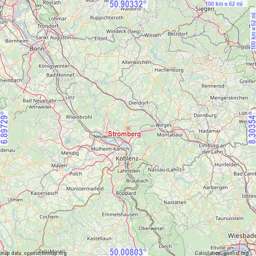
50° 27' 28.044" North, 7° 36' 1.476" East
| Map corner | latitude | longitude |
|---|---|---|
| Upper-left | 50.90332°, | 6.89729° |
| Center: | 50.45779°, | 7.60041° |
| Lower-right: | 50.00803°, | 8.30354° |
| Map W x H: | 99.5×99.5 km | = 61.8×61.8mi |
| max Lat: | 55.01917° ⇑53.6% North |
| Stromberg: | 50.45779° |
| min Lat: | ⇓46.4% South 47.40724° |
| min Long | Stromberg | max Long |
| 5.92978° | 7.60041° | 14.98853° |
| W 15.1%⇐ | ⇒84.9% E |
Elevation
Elevation of Stromberg is 300 m = 984 ft, and this is 50.9 m = 167 ft above average elevation for this country.
| Max E: |
1256 m = 4121 ft | 38.3% |
| Stromberg | 300 m 984 ft | |
| Avg. | 249.1 m = 817 ft | |
Min E: |
-5 m = -16 ft | 61.7% |
See also: Germany elevation on elevation.city.
Geographical zone
Stromberg is located in North temperate zone (between Tropic of Cancer and the Arctic Circle). Distance of this North polar circle is 1790.8 km =1112.8 mi to North.| Distance of | km | miles | from Stromberg |
|---|---|---|---|
| North Pole | 4396.7 | 2732 | to North |
| Arctic Circle | 1790.8 | 1112.8 | to North |
| Tropic Cancer | 3004.5 | 1866.9 | to South |
| Equator | 5610.4 | 3486.1 | to South |


Nearby cities:
15 places around Stromberg: (largest is in red/bold)
• Alsbach
4.4 km =2.7 mi,  80°
80°
• Bendorf
4.2 km =2.6 mi,  201°
201°
• Caan
1.5 km =0.9 mi,  49°
49°
• Großmaischeid
5.2 km =3.2 mi,  26°
26°
• Heimbach
4.8 km =3 mi,  259°
259°
• Höhr-Grenzhausen
5.5 km =3.4 mi,  117°
117°
• Isenburg
2.8 km =1.7 mi,  359°
359°
• Kaltenengers
5.8 km =3.6 mi,  217°
217°
• Kammerforst
5.4 km =3.4 mi, 83°
• Meinborn
5.3 km =3.3 mi,  333°
333°
• Nauort
2.5 km =1.6 mi,  67°
67°
• Sessenbach
3.8 km =2.4 mi,  55°
55°
• Thalhausen
4.8 km =3 mi,  345°
345°
• Weitersburg
4.6 km =2.9 mi,  180°
180°
• Wirscheid
4.8 km =3 mi, 78°
Sources, notices
• [Note1] Compared only with cities in Germany existing in our database
• [Src1] Map data: © OpenStreetMap contributors (CC-BY-SA)
• [Src2] Other city data from geonames.org with taken over terms of usage.
• [Src3] Geographical zone / Annual Mean Temperature by Robert A. Rohde @ Wikipedia
