Höhr-Grenzhausen geodata
Höhr-Grenzhausen (Rheinland-Pfalz) is a populated place; located in Germany in Europe/Berlin (GMT+2) time zone. With population of 9,794 people, there are 1656 cities with bigger population in this country. Compared to other cities in Germany, 53.9% of cities are located further ↑North; 83.5% of cities are located further →East and 54.7% of cities have lower elevation than Höhr-Grenzhausen. Note1
Administrative division(s):
- Level 1: Rheinland-Pfalz
- Level 3: Westerwaldkreis
- Level 4: Höhr-Grenzhausen


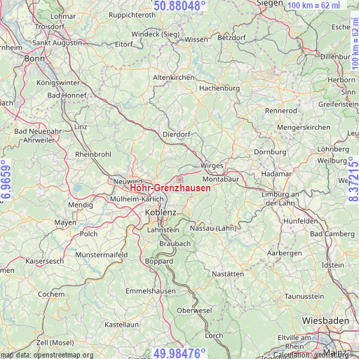
Höhr-Grenzhausen GPS coordinates[2]
50° 26' 5.064" North, 7° 40' 8.508" East
| Map corner | latitude | longitude |
|---|---|---|
| Upper-left | 50.88048°, | 6.9659° |
| Center: | 50.43474°, | 7.66903° |
| Lower-right: | 49.98476°, | 8.37215° |
| Map W x H: | 99.6×99.6 km | = 61.9×61.9mi |
| max Lat: | 55.01917° ⇑53.9% North |
| Höhr-Grenzhausen: | 50.43474° |
| min Lat: | ⇓46.1% South 47.40724° |
| min Long | Höhr-Grenzhaus | max Long |
| 5.92978° | 7.66903° | 14.98853° |
| W 16.5%⇐ | ⇒83.5% E |
Elevation
Elevation of Höhr-Grenzhausen is 256 m = 840 ft, and this is 6.9 m = 23 ft above average elevation for this country.
| Max E: |
1256 m = 4121 ft | 45.3% |
| Höhr-Grenzhausen | 256 m 840 ft | |
| Avg. | 249.1 m = 817 ft | |
Min E: |
-5 m = -16 ft | 54.7% |
See also: Germany elevation on elevation.city.
Geographical zone
Höhr-Grenzhausen is located in North temperate zone (between Tropic of Cancer and the Arctic Circle). Distance of this North polar circle is 1793.4 km =1114.4 mi to North.| Distance of | km | miles | from Höhr-Grenzhausen |
|---|---|---|---|
| North Pole | 4399.2 | 2733.5 | to North |
| Arctic Circle | 1793.4 | 1114.4 | to North |
| Tropic Cancer | 3001.9 | 1865.3 | to South |
| Equator | 5607.8 | 3484.5 | to South |


Nearby cities:
15 places around Höhr-Grenzhausen: (largest is in red/bold)
• Alsbach
3.3 km =2.1 mi,  351°
351°
• Caan
5.1 km =3.2 mi,  313°
313°
• Hilgert
2.7 km =1.7 mi,  28°
28°
• Hillscheid
3.8 km =2.4 mi,  146°
146°
• Hundsdorf
4.6 km =2.9 mi, 30°
• Kammerforst
3.2 km =2 mi,  8°
8°
• Nauort
4.4 km =2.7 mi,  324°
324°
• Niederwerth
5.4 km =3.4 mi,  223°
223°
• Ransbach-Baumbach
5.4 km =3.4 mi,  51°
51°
• Sessenbach
5 km =3.1 mi,  339°
339°
• Simmern
5.1 km =3.2 mi,  176°
176°
• Stromberg
5.5 km =3.4 mi,  297°
297°
• Vallendar
5.4 km =3.4 mi, 216°
• Weitersburg
5.3 km =3.3 mi,  247°
247°
• Wirscheid
3.6 km =2.2 mi,  357°
357°
Sources, notices
• [Note1] Compared only with cities in Germany existing in our database
• [Src1] Map data: © OpenStreetMap contributors (CC-BY-SA)
• [Src2] Other city data from geonames.org with taken over terms of usage.
• [Src3] Geographical zone / Annual Mean Temperature by Robert A. Rohde @ Wikipedia
