Heimbach geodata
Heimbach (Rheinland-Pfalz) is a section of populated place; located in Germany in Europe/Berlin (GMT+2) time zone. With population of 1,241 people, there are 6469 cities with bigger population in this country. Compared to other cities in Germany, 53.8% of cities are located further ↑North; 86.4% of cities are located further →East and 70.5% of cities have higher elevation than Heimbach. Note1


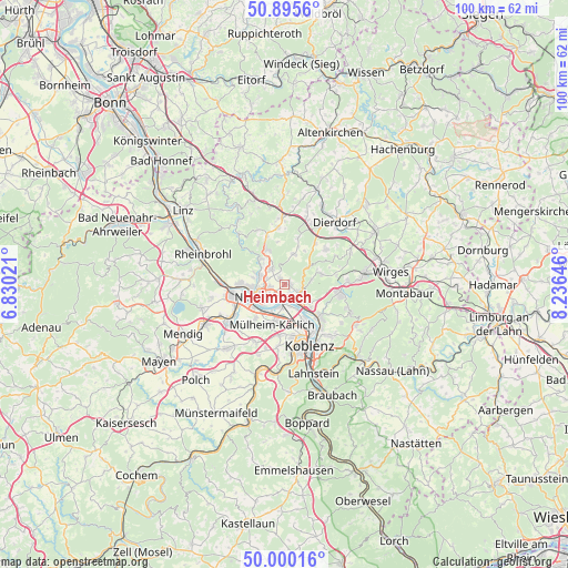
Heimbach GPS coordinates[2]
50° 27' 0" North, 7° 31' 59.988" East
| Map corner | latitude | longitude |
|---|---|---|
| Upper-left | 50.8956°, | 6.83021° |
| Center: | 50.45°, | 7.53333° |
| Lower-right: | 50.00016°, | 8.23646° |
| Map W x H: | 99.6×99.6 km | = 61.9×61.9mi |
| max Lat: | 55.01917° ⇑53.8% North |
| Heimbach: | 50.45° |
| min Lat: | ⇓46.2% South 47.40724° |
| min Long | Heimbach | max Long |
| 5.92978° | 7.53333° | 14.98853° |
| W 13.6%⇐ | ⇒86.4% E |
Elevation
Elevation of Heimbach is 88 m = 289 ft, and this is 161.1 m = 529 ft below average elevation for this country.
| Max E: |
1256 m = 4121 ft | 70.5% |
| Avg. | 249.1 m = 817 ft | |
| Heimbach | 88 m = 289 ft | |
Min E: |
-5 m = -16 ft | 29.5% |
See also: Germany elevation on elevation.city.
Geographical zone
Heimbach is located in North temperate zone (between Tropic of Cancer and the Arctic Circle). Distance of this North polar circle is 1791.7 km =1113.3 mi to North.| Distance of | km | miles | from Heimbach |
|---|---|---|---|
| North Pole | 4397.5 | 2732.5 | to North |
| Arctic Circle | 1791.7 | 1113.3 | to North |
| Tropic Cancer | 3003.6 | 1866.3 | to South |
| Equator | 5609.5 | 3485.6 | to South |


Nearby cities:
15 places around Heimbach: (largest is in red/bold)
• Anhausen
5.7 km =3.5 mi,  11°
11°
• Bendorf
4.4 km =2.7 mi,  132°
132°
• Caan
6.2 km =3.9 mi,  72°
72°
• Isenburg
6 km =3.7 mi,  51°
51°
• Kaltenengers
3.9 km =2.4 mi,  162°
162°
• Meinborn
6 km =3.7 mi,  22°
22°
• Melsbach
5.1 km =3.2 mi,  316°
316°
• Neuwied
4.8 km =3 mi,  247°
247°
• Rengsdorf
6 km =3.7 mi,  337°
337°
• Sankt Sebastian
4.8 km =3 mi, 155°
• Stromberg
4.8 km =3 mi,  79°
79°
• Thalhausen
6.6 km =4.1 mi,  32°
32°
• Urmitz
3.9 km =2.4 mi,  197°
197°
• Weitersburg
6 km =3.7 mi, 128°
• Weißenthurm
6.9 km =4.3 mi,  238°
238°
Sources, notices
• [Note1] Compared only with cities in Germany existing in our database
• [Src1] Map data: © OpenStreetMap contributors (CC-BY-SA)
• [Src2] Other city data from geonames.org with taken over terms of usage.
• [Src3] Geographical zone / Annual Mean Temperature by Robert A. Rohde @ Wikipedia
