Stördorf geodata
Stördorf (Schleswig-Holstein) is a seat of a fourth-order administrative division; located in Germany in Europe/Berlin (GMT+2) time zone. With population of 132 people, there are 10753 cities with bigger population in this country. Compared to other cities in Germany, 91.5% of cities are located further ↓South; 58.9% of cities are located further →East and 99.5% of cities have higher elevation than Stördorf. Note1


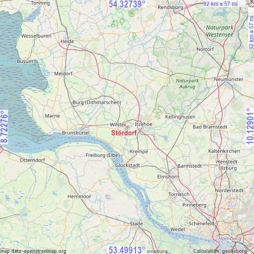
Stördorf GPS coordinates[2]
53° 54' 55.116" North, 9° 25' 33.168" East
| Map corner | latitude | longitude |
|---|---|---|
| Upper-left | 54.32739°, | 8.72276° |
| Center: | 53.91531°, | 9.42588° |
| Lower-right: | 53.49913°, | 10.12901° |
| Map W x H: | 92.1×92.1 km | = 57.2×57.2mi |
| max Lat: | 55.01917° ⇑8.5% North |
| Stördorf: | 53.91531° |
| min Lat: | ⇓91.5% South 47.40724° |
| min Long | Stördorf | max Long |
| 5.92978° | 9.42588° | 14.98853° |
| W 41.1%⇐ | ⇒58.9% E |
Elevation
Elevation of Stördorf is -1 m = -3 ft, and this is 250.1 m = 821 ft below average elevation for this country.
| Max E: |
1256 m = 4121 ft | 99.5% |
| Avg. | 249.1 m = 817 ft | |
| Stördorf | -1 m = -3 ft | |
Min E: |
-5 m = -16 ft | 0.5% |
See also: Germany elevation on elevation.city.
Geographical zone
Stördorf is located in North temperate zone (between Tropic of Cancer and the Arctic Circle). Distance of this North polar circle is 1406.4 km =873.9 mi to North.| Distance of | km | miles | from Stördorf |
|---|---|---|---|
| North Pole | 4012.2 | 2493.1 | to North |
| Arctic Circle | 1406.4 | 873.9 | to North |
| Tropic Cancer | 3388.9 | 2105.8 | to South |
| Equator | 5994.8 | 3725 | to South |


Nearby cities:
15 places around Stördorf: (largest is in red/bold)
• Bahrenfleth
5 km =3.1 mi,  169°
169°
• Beidenfleth
4.1 km =2.5 mi,  191°
191°
• Bekdorf
2.7 km =1.7 mi,  355°
355°
• Bekmünde
1.7 km =1.1 mi,  51°
51°
• Dammfleth
3.5 km =2.2 mi,  258°
258°
• Heiligenstedten
3.7 km =2.3 mi,  58°
58°
• Heiligenstedtenerkamp
3.3 km =2.1 mi,  122°
122°
• Hodorf
1.7 km =1.1 mi, 170°
• Kremperheide
4.6 km =2.9 mi,  132°
132°
• Krempermoor
5.6 km =3.5 mi,  139°
139°
• Krummendiek
3.5 km =2.2 mi,  350°
350°
• Landrecht
4.4 km =2.7 mi,  297°
297°
• Moorhusen
5.6 km =3.5 mi,  330°
330°
• Oldendorf
4.7 km =2.9 mi,  26°
26°
• Wilster
3.4 km =2.1 mi,  283°
283°
Sources, notices
• [Note1] Compared only with cities in Germany existing in our database
• [Src1] Map data: © OpenStreetMap contributors (CC-BY-SA)
• [Src2] Other city data from geonames.org with taken over terms of usage.
• [Src3] Geographical zone / Annual Mean Temperature by Robert A. Rohde @ Wikipedia
