Stockach geodata
Stockach (Baden-Württemberg) is a populated place; located in Germany in Europe/Berlin (GMT+1) time zone. With population of 16,844 people, there are 941 cities with bigger population in this country. Compared to other cities in Germany, 97.1% of cities are located further ↑North; 65.3% of cities are located further →East and 85.6% of cities have lower elevation than Stockach. Note1
Administrative division(s):
- Level 1: Baden-Württemberg
- Level 2: Freiburg Region
- Level 3: Landkreis Konstanz
- Level 4: Stockach


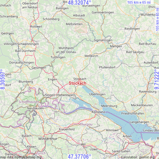
Stockach GPS coordinates[2]
47° 51' 3.78" North, 9° 0' 32.76" East
| Map corner | latitude | longitude |
|---|---|---|
| Upper-left | 48.32074°, | 8.30597° |
| Center: | 47.85105°, | 9.0091° |
| Lower-right: | 47.37706°, | 9.71222° |
| Map W x H: | 104.9×104.9 km | = 65.2×65.2mi |
| max Lat: | 55.01917° ⇑97.1% North |
| Stockach: | 47.85105° |
| min Lat: | ⇓2.9% South 47.40724° |
| min Long | Stockach | max Long |
| 5.92978° | 9.0091° | 14.98853° |
| W 34.7%⇐ | ⇒65.3% E |
Elevation
Elevation of Stockach is 474 m = 1555 ft, and this is 224.9 m = 738 ft above average elevation for this country.
| Max E: |
1256 m = 4121 ft | 14.4% |
| Stockach | 474 m 1555 ft | |
| Avg. | 249.1 m = 817 ft | |
Min E: |
-5 m = -16 ft | 85.6% |
See also: Germany elevation on elevation.city.
Geographical zone
Stockach is located in North temperate zone (between Tropic of Cancer and the Arctic Circle). Distance of this North polar circle is 2080.6 km =1292.8 mi to North.| Distance of | km | miles | from Stockach |
|---|---|---|---|
| North Pole | 4686.5 | 2912.1 | to North |
| Arctic Circle | 2080.6 | 1292.8 | to North |
| Tropic Cancer | 2714.6 | 1686.8 | to South |
| Equator | 5320.5 | 3306 | to South |


Nearby cities:
15 places around Stockach: (largest is in red/bold)
• Aach
11.6 km =7.2 mi,  265°
265°
• Bodman-Ludwigshafen
5 km =3.1 mi,  136°
136°
• Eigeltingen
8.3 km =5.2 mi,  275°
275°
• Emmingen-Liptingen
13.1 km =8.1 mi,  314°
314°
• Herdwangen-Schönach
14.2 km =8.8 mi,  90°
90°
• Mühlingen
7.3 km =4.5 mi,  4°
4°
• Neuhausen ob Eck
14.8 km =9.2 mi,  335°
335°
• Orsingen-Nenzingen
3.8 km =2.4 mi,  256°
256°
• Owingen
13 km =8.1 mi,  110°
110°
• Radolfzell
12.5 km =7.8 mi,  193°
193°
• Rot
10.7 km =6.6 mi,  41°
41°
• Sauldorf
12.7 km =7.9 mi, 35°
• Sipplingen
8.9 km =5.5 mi,  132°
132°
• Steißlingen
8 km =5 mi,  224°
224°
• Volkertshausen
11.3 km =7 mi,  250°
250°
Sources, notices
• [Note1] Compared only with cities in Germany existing in our database
• [Src1] Map data: © OpenStreetMap contributors (CC-BY-SA)
• [Src2] Other city data from geonames.org with taken over terms of usage.
• [Src3] Geographical zone / Annual Mean Temperature by Robert A. Rohde @ Wikipedia
