Herdwangen-Schönach geodata
Herdwangen-Schönach (Baden-Württemberg) is a seat of a fourth-order administrative division; located in Germany in Europe/Berlin (GMT+2) time zone. With population of 3,240 people, there are 3796 cities with bigger population in this country. Compared to other cities in Germany, 97.1% of cities are located further ↑North; 62.4% of cities are located further →East and 95.3% of cities have lower elevation than Herdwangen-Schönach. Note1
Administrative division(s):
- Level 1: Baden-Württemberg
- Level 2: Tübingen Region
- Level 3: Landkreis Sigmaringen
- Level 4: Herdwangen-Schönach


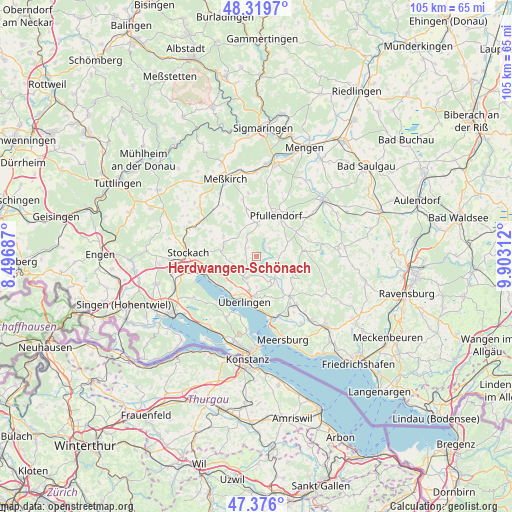
Herdwangen-Schönach GPS coordinates[2]
47° 51' 0" North, 9° 12' 0" East
| Map corner | latitude | longitude |
|---|---|---|
| Upper-left | 48.3197°, | 8.49687° |
| Center: | 47.85°, | 9.2° |
| Lower-right: | 47.376°, | 9.90312° |
| Map W x H: | 104.9×104.9 km | = 65.2×65.2mi |
| max Lat: | 55.01917° ⇑97.1% North |
| Herdwangen-Schönach: | 47.85° |
| min Lat: | ⇓2.9% South 47.40724° |
| min Long | Herdwangen-Sch� | max Long |
| 5.92978° | 9.2° | 14.98853° |
| W 37.6%⇐ | ⇒62.4% E |
Elevation
Elevation of Herdwangen-Schönach is 606 m = 1988 ft, and this is 356.9 m = 1171 ft above average elevation for this country.
| Max E: |
1256 m = 4121 ft | 4.7% |
| Herdwangen-Schönach | 606 m 1988 ft | |
| Avg. | 249.1 m = 817 ft | |
Min E: |
-5 m = -16 ft | 95.3% |
See also: Germany elevation on elevation.city.
Geographical zone
Herdwangen-Schönach is located in North temperate zone (between Tropic of Cancer and the Arctic Circle). Distance of this North polar circle is 2080.8 km =1292.9 mi to North.| Distance of | km | miles | from Herdwangen-Schönach |
|---|---|---|---|
| North Pole | 4686.6 | 2912.1 | to North |
| Arctic Circle | 2080.8 | 1292.9 | to North |
| Tropic Cancer | 2714.5 | 1686.7 | to South |
| Equator | 5320.4 | 3305.9 | to South |


Nearby cities:
15 places around Herdwangen-Schönach: (largest is in red/bold)
• Bodman-Ludwigshafen
11.4 km =7.1 mi,  251°
251°
• Frickingen
6.8 km =4.2 mi,  125°
125°
• Heiligenberg
9 km =5.6 mi,  110°
110°
• Illmensee
12.9 km =8 mi,  83°
83°
• Mühlingen
15.6 km =9.7 mi,  298°
298°
• Owingen
5 km =3.1 mi,  205°
205°
• Pfullendorf
9.5 km =5.9 mi,  26°
26°
• Rot
10.8 km =6.7 mi,  318°
318°
• Salem
11.8 km =7.3 mi,  145°
145°
• Sauldorf
12.5 km =7.8 mi,  326°
326°
• Sipplingen
9.7 km =6 mi,  232°
232°
• Stockach
14.2 km =8.8 mi,  270°
270°
• Uhldingen-Mühlhofen
13.5 km =8.4 mi,  163°
163°
• Wald
9.6 km =6 mi,  344°
344°
• Überlingen
9.2 km =5.7 mi,  193°
193°
Sources, notices
• [Note1] Compared only with cities in Germany existing in our database
• [Src1] Map data: © OpenStreetMap contributors (CC-BY-SA)
• [Src2] Other city data from geonames.org with taken over terms of usage.
• [Src3] Geographical zone / Annual Mean Temperature by Robert A. Rohde @ Wikipedia
