Stelle-Wittenwurth geodata
Stelle-Wittenwurth (Schleswig-Holstein) is a seat of a fourth-order administrative division; located in Germany in Europe/Berlin (GMT+2) time zone. With population of 467 people, there are 9483 cities with bigger population in this country. Compared to other cities in Germany, 95.9% of cities are located further ↓South; 64.8% of cities are located further →East and 97% of cities have higher elevation than Stelle-Wittenwurth. Note1
Administrative division(s):
- Level 1: Schleswig-Holstein
- Level 3: Kreis Dithmarschen
- Level 4: Stelle-Wittenwurth


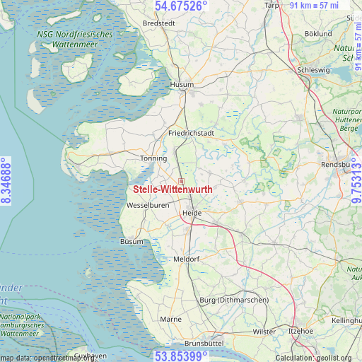
Stelle-Wittenwurth GPS coordinates[2]
54° 16' 0.012" North, 9° 3' 0" East
| Map corner | latitude | longitude |
|---|---|---|
| Upper-left | 54.67526°, | 8.34688° |
| Center: | 54.26667°, | 9.05° |
| Lower-right: | 53.85399°, | 9.75313° |
| Map W x H: | 91.3×91.3 km | = 56.7×56.7mi |
| max Lat: | 55.01917° ⇑4.1% North |
| Stelle-Wittenwurth: | 54.26667° |
| min Lat: | ⇓95.9% South 47.40724° |
| min Long | Stelle-Wittenwu | max Long |
| 5.92978° | 9.05° | 14.98853° |
| W 35.2%⇐ | ⇒64.8% E |
Elevation
Elevation of Stelle-Wittenwurth is 4 m = 13 ft, and this is 245.1 m = 804 ft below average elevation for this country.
| Max E: |
1256 m = 4121 ft | 97% |
| Avg. | 249.1 m = 817 ft | |
| Stelle-Wittenwurth | 4 m = 13 ft | |
Min E: |
-5 m = -16 ft | 3% |
See also: Germany elevation on elevation.city.
Geographical zone
Stelle-Wittenwurth is located in North temperate zone (between Tropic of Cancer and the Arctic Circle). Distance of this North polar circle is 1367.3 km =849.6 mi to North.| Distance of | km | miles | from Stelle-Wittenwurth |
|---|---|---|---|
| North Pole | 3973.2 | 2468.8 | to North |
| Arctic Circle | 1367.3 | 849.6 | to North |
| Tropic Cancer | 3428 | 2130.1 | to South |
| Equator | 6033.9 | 3749.3 | to South |


Nearby cities:
15 places around Stelle-Wittenwurth: (largest is in red/bold)
• Fedderingen
5.7 km =3.5 mi,  71°
71°
• Groven
5.7 km =3.5 mi,  310°
310°
• Hemme
2.8 km =1.7 mi, 310°
• Karolinenkoog
5.7 km =3.5 mi,  288°
288°
• Kleve
5.8 km =3.6 mi,  56°
56°
• Krempel
5.7 km =3.5 mi,  348°
348°
• Neuenkirchen
5.1 km =3.2 mi,  228°
228°
• Norderheistedt
6.8 km =4.2 mi,  105°
105°
• Oesterwurth
7 km =4.3 mi,  217°
217°
• Rehm-Flehde-Bargen
2.8 km =1.7 mi, 310°
• Schlichting
5.5 km =3.4 mi,  27°
27°
• Strübbel
5.4 km =3.4 mi,  270°
270°
• Weddingstedt
4.5 km =2.8 mi,  143°
143°
• Wesseln
6.5 km =4 mi,  164°
164°
• Wiemerstedt
4.3 km =2.7 mi,  90°
90°
Sources, notices
• [Note1] Compared only with cities in Germany existing in our database
• [Src1] Map data: © OpenStreetMap contributors (CC-BY-SA)
• [Src2] Other city data from geonames.org with taken over terms of usage.
• [Src3] Geographical zone / Annual Mean Temperature by Robert A. Rohde @ Wikipedia
