Groven geodata
Groven (Schleswig-Holstein) is a seat of a fourth-order administrative division; located in Germany in Europe/Berlin (GMT+2) time zone. With population of 121 people, there are 10785 cities with bigger population in this country. Compared to other cities in Germany, 96.2% of cities are located further ↓South; 65.7% of cities are located further →East and 99.5% of cities have higher elevation than Groven. Note1


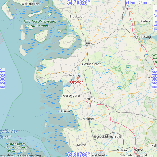
Groven GPS coordinates[2]
54° 18' 0" North, 8° 58' 59.988" East
| Map corner | latitude | longitude |
|---|---|---|
| Upper-left | 54.70826°, | 8.28021° |
| Center: | 54.3°, | 8.98333° |
| Lower-right: | 53.88765°, | 9.68646° |
| Map W x H: | 91.2×91.2 km | = 56.7×56.7mi |
| max Lat: | 55.01917° ⇑3.8% North |
| Groven: | 54.3° |
| min Lat: | ⇓96.2% South 47.40724° |
| min Long | Groven | max Long |
| 5.92978° | 8.98333° | 14.98853° |
| W 34.3%⇐ | ⇒65.7% E |
Elevation
Elevation of Groven is -1 m = -3 ft, and this is 250.1 m = 821 ft below average elevation for this country.
| Max E: |
1256 m = 4121 ft | 99.5% |
| Avg. | 249.1 m = 817 ft | |
| Groven | -1 m = -3 ft | |
Min E: |
-5 m = -16 ft | 0.5% |
See also: Germany elevation on elevation.city.
Geographical zone
Groven is located in North temperate zone (between Tropic of Cancer and the Arctic Circle). Distance of this North polar circle is 1363.6 km =847.3 mi to North.| Distance of | km | miles | from Groven |
|---|---|---|---|
| North Pole | 3969.5 | 2466.5 | to North |
| Arctic Circle | 1363.6 | 847.3 | to North |
| Tropic Cancer | 3431.7 | 2132.4 | to South |
| Equator | 6037.6 | 3751.6 | to South |


Nearby cities:
15 places around Groven: (largest is in red/bold)
• Hemme
2.8 km =1.7 mi,  130°
130°
• Karolinenkoog
2.1 km =1.3 mi,  210°
210°
• Kotzenbüll
6.3 km =3.9 mi,  305°
305°
• Krempel
3.7 km =2.3 mi,  60°
60°
• Lehe
5.3 km =3.3 mi,  29°
29°
• Lunden
4.4 km =2.7 mi,  37°
37°
• Neuenkirchen
7.1 km =4.4 mi,  175°
175°
• Rehm-Flehde-Bargen
2.8 km =1.7 mi, 130°
• Sankt Annen
8.1 km =5 mi,  50°
50°
• Schlichting
7 km =4.3 mi,  80°
80°
• Schülp
7.2 km =4.5 mi, 207°
• Stelle-Wittenwurth
5.7 km =3.5 mi, 130°
• Strübbel
3.9 km =2.4 mi,  196°
196°
• Tönning
3.4 km =2.1 mi, 308°
• Wesselburenerkoog
8.5 km =5.3 mi,  229°
229°
Sources, notices
• [Note1] Compared only with cities in Germany existing in our database
• [Src1] Map data: © OpenStreetMap contributors (CC-BY-SA)
• [Src2] Other city data from geonames.org with taken over terms of usage.
• [Src3] Geographical zone / Annual Mean Temperature by Robert A. Rohde @ Wikipedia
