Rehm-Flehde-Bargen geodata
Rehm-Flehde-Bargen (Schleswig-Holstein) is a seat of a fourth-order administrative division; located in Germany in Europe/Berlin (GMT+2) time zone. With population of 619 people, there are 8726 cities with bigger population in this country. Compared to other cities in Germany, 96% of cities are located further ↓South; 65.2% of cities are located further →East and 99.5% of cities have higher elevation than Rehm-Flehde-Bargen. Note1
Administrative division(s):
- Level 1: Schleswig-Holstein
- Level 3: Kreis Dithmarschen
- Level 4: Rehm-Flehde-Bargen


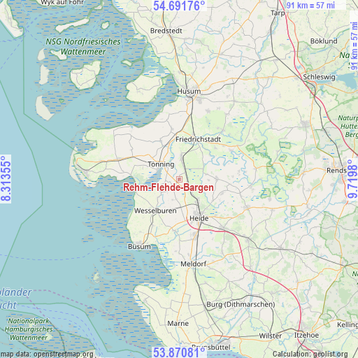
Rehm-Flehde-Bargen GPS coordinates[2]
54° 16' 59.988" North, 9° 1' 0.012" East
| Map corner | latitude | longitude |
|---|---|---|
| Upper-left | 54.69176°, | 8.31355° |
| Center: | 54.28333°, | 9.01667° |
| Lower-right: | 53.87081°, | 9.7198° |
| Map W x H: | 91.3×91.3 km | = 56.7×56.7mi |
| max Lat: | 55.01917° ⇑4% North |
| Rehm-Flehde-Bargen: | 54.28333° |
| min Lat: | ⇓96% South 47.40724° |
| min Long | Rehm-Flehde-Bar | max Long |
| 5.92978° | 9.01667° | 14.98853° |
| W 34.8%⇐ | ⇒65.2% E |
Elevation
Elevation of Rehm-Flehde-Bargen is -1 m = -3 ft, and this is 250.1 m = 821 ft below average elevation for this country.
| Max E: |
1256 m = 4121 ft | 99.5% |
| Avg. | 249.1 m = 817 ft | |
| Rehm-Flehde-Bargen | -1 m = -3 ft | |
Min E: |
-5 m = -16 ft | 0.5% |
See also: Germany elevation on elevation.city.
Geographical zone
Rehm-Flehde-Bargen is located in North temperate zone (between Tropic of Cancer and the Arctic Circle). Distance of this North polar circle is 1365.4 km =848.4 mi to North.| Distance of | km | miles | from Rehm-Flehde-Bargen |
|---|---|---|---|
| North Pole | 3971.3 | 2467.7 | to North |
| Arctic Circle | 1365.4 | 848.4 | to North |
| Tropic Cancer | 3429.8 | 2131.2 | to South |
| Equator | 6035.7 | 3750.4 | to South |


Nearby cities:
15 places around Rehm-Flehde-Bargen: (largest is in red/bold)
• Groven
2.8 km =1.7 mi,  310°
310°
• Hemme
0 km =0 mi,  0°
0°
• Karolinenkoog
3.2 km =2 mi,  270°
270°
• Kleve
7.1 km =4.4 mi,  79°
79°
• Krempel
3.9 km =2.4 mi,  16°
16°
• Lehe
6.5 km =4 mi, 4°
• Lunden
5.4 km =3.4 mi,  5°
5°
• Neuenkirchen
5.5 km =3.4 mi,  197°
197°
• Schlichting
5.6 km =3.5 mi,  57°
57°
• Schülp
7.1 km =4.4 mi,  230°
230°
• Stelle-Wittenwurth
2.8 km =1.7 mi,  130°
130°
• Strübbel
3.7 km =2.3 mi,  240°
240°
• Tönning
6.2 km =3.9 mi, 309°
• Weddingstedt
7.3 km =4.5 mi,  138°
138°
• Wiemerstedt
6.8 km =4.2 mi,  105°
105°
Sources, notices
• [Note1] Compared only with cities in Germany existing in our database
• [Src1] Map data: © OpenStreetMap contributors (CC-BY-SA)
• [Src2] Other city data from geonames.org with taken over terms of usage.
• [Src3] Geographical zone / Annual Mean Temperature by Robert A. Rohde @ Wikipedia
