Schlichting geodata
Schlichting (Schleswig-Holstein) is a seat of a fourth-order administrative division; located in Germany in Europe/Berlin (GMT+2) time zone. With population of 238 people, there are 10312 cities with bigger population in this country. Compared to other cities in Germany, 96.4% of cities are located further ↓South; 64.2% of cities are located further →East and 99.9% of cities have higher elevation than Schlichting. Note1
Administrative division(s):
- Level 1: Schleswig-Holstein
- Level 3: Kreis Dithmarschen
- Level 4: Schlichting


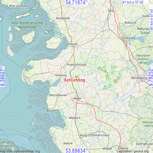
Schlichting GPS coordinates[2]
54° 18' 38.088" North, 9° 5' 21.804" East
| Map corner | latitude | longitude |
|---|---|---|
| Upper-left | 54.71874°, | 8.38627° |
| Center: | 54.31058°, | 9.08939° |
| Lower-right: | 53.89834°, | 9.79252° |
| Map W x H: | 91.2×91.2 km | = 56.7×56.7mi |
| max Lat: | 55.01917° ⇑3.6% North |
| Schlichting: | 54.31058° |
| min Lat: | ⇓96.4% South 47.40724° |
| min Long | Schlichting | max Long |
| 5.92978° | 9.08939° | 14.98853° |
| W 35.8%⇐ | ⇒64.2% E |
Elevation
Elevation of Schlichting is -3 m = -10 ft, and this is 252.1 m = 827 ft below average elevation for this country.
| Max E: |
1256 m = 4121 ft | 99.9% |
| Avg. | 249.1 m = 817 ft | |
| Schlichting | -3 m = -10 ft | |
Min E: |
-5 m = -16 ft | 0.1% |
See also: Germany elevation on elevation.city.
Geographical zone
Schlichting is located in North temperate zone (between Tropic of Cancer and the Arctic Circle). Distance of this North polar circle is 1362.4 km =846.6 mi to North.| Distance of | km | miles | from Schlichting |
|---|---|---|---|
| North Pole | 3968.3 | 2465.8 | to North |
| Arctic Circle | 1362.4 | 846.6 | to North |
| Tropic Cancer | 3432.9 | 2133.1 | to South |
| Equator | 6038.8 | 3752.3 | to South |


Nearby cities:
15 places around Schlichting: (largest is in red/bold)
• Drage
6.7 km =4.2 mi,  41°
41°
• Fedderingen
4.2 km =2.6 mi,  136°
136°
• Friedrichstadt
7.2 km =4.5 mi,  358°
358°
• Groven
7 km =4.3 mi,  260°
260°
• Hemme
5.6 km =3.5 mi,  237°
237°
• Hennstedt
5.9 km =3.7 mi,  121°
121°
• Kleve
2.8 km =1.7 mi,  127°
127°
• Krempel
3.7 km =2.3 mi,  280°
280°
• Lehe
5.5 km =3.4 mi,  308°
308°
• Lunden
4.8 km =3 mi,  298°
298°
• Norderheistedt
7.8 km =4.8 mi,  149°
149°
• Rehm-Flehde-Bargen
5.6 km =3.5 mi, 237°
• Sankt Annen
4.1 km =2.5 mi,  350°
350°
• Stelle-Wittenwurth
5.5 km =3.4 mi,  207°
207°
• Wiemerstedt
5.2 km =3.2 mi,  160°
160°
Sources, notices
• [Note1] Compared only with cities in Germany existing in our database
• [Src1] Map data: © OpenStreetMap contributors (CC-BY-SA)
• [Src2] Other city data from geonames.org with taken over terms of usage.
• [Src3] Geographical zone / Annual Mean Temperature by Robert A. Rohde @ Wikipedia
