Stegen geodata
Stegen (Baden-Württemberg) is a seat of a fourth-order administrative division; located in Germany in Europe/Berlin (GMT+1) time zone. With population of 4,490 people, there are 3043 cities with bigger population in this country. Compared to other cities in Germany, 95.7% of cities are located further ↑North; 77.8% of cities are located further →East and 73.5% of cities have lower elevation than Stegen. Note1
Administrative division(s):
- Level 1: Baden-Württemberg
- Level 2: Freiburg Region
- Level 3: Landkreis Breisgau-Hochschwarzwald
- Level 4: Stegen


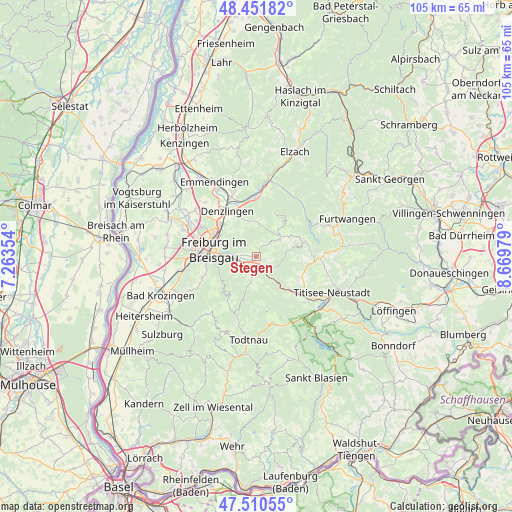
Stegen GPS coordinates[2]
47° 58' 59.988" North, 7° 58' 0.012" East
| Map corner | latitude | longitude |
|---|---|---|
| Upper-left | 48.45182°, | 7.26354° |
| Center: | 47.98333°, | 7.96667° |
| Lower-right: | 47.51055°, | 8.66979° |
| Map W x H: | 104.7×104.7 km | = 65.1×65.1mi |
| max Lat: | 55.01917° ⇑95.7% North |
| Stegen: | 47.98333° |
| min Lat: | ⇓4.3% South 47.40724° |
| min Long | Stegen | max Long |
| 5.92978° | 7.96667° | 14.98853° |
| W 22.2%⇐ | ⇒77.8% E |
Elevation
Elevation of Stegen is 386 m = 1266 ft, and this is 136.9 m = 449 ft above average elevation for this country.
| Max E: |
1256 m = 4121 ft | 26.5% |
| Stegen | 386 m 1266 ft | |
| Avg. | 249.1 m = 817 ft | |
Min E: |
-5 m = -16 ft | 73.5% |
See also: Germany elevation on elevation.city.
Geographical zone
Stegen is located in North temperate zone (between Tropic of Cancer and the Arctic Circle). Distance of this North polar circle is 2065.9 km =1283.7 mi to North.| Distance of | km | miles | from Stegen |
|---|---|---|---|
| North Pole | 4671.8 | 2902.9 | to North |
| Arctic Circle | 2065.9 | 1283.7 | to North |
| Tropic Cancer | 2729.3 | 1695.9 | to South |
| Equator | 5335.2 | 3315.1 | to South |


Nearby cities:
15 places around Stegen: (largest is in red/bold)
• Au
10.6 km =6.6 mi,  249°
249°
• Breitnau
10.3 km =6.4 mi,  122°
122°
• Buchenbach
4 km =2.5 mi,  127°
127°
• Denzlingen
11.1 km =6.9 mi,  326°
326°
• Freiburg
8.6 km =5.3 mi,  279°
279°
• Glottertal
7.5 km =4.7 mi,  358°
358°
• Gundelfingen
10 km =6.2 mi,  311°
311°
• Heuweiler
8.9 km =5.5 mi, 326°
• Horben
9.3 km =5.8 mi,  233°
233°
• Kirchzarten
2.2 km =1.4 mi,  213°
213°
• Merzhausen
10.1 km =6.3 mi,  259°
259°
• Oberried
5.7 km =3.5 mi,  192°
192°
• Sankt Märgen
9.8 km =6.1 mi,  73°
73°
• Sankt Peter
6 km =3.7 mi,  54°
54°
• St. Peter
6.1 km =3.8 mi, 53°
Sources, notices
• [Note1] Compared only with cities in Germany existing in our database
• [Src1] Map data: © OpenStreetMap contributors (CC-BY-SA)
• [Src2] Other city data from geonames.org with taken over terms of usage.
• [Src3] Geographical zone / Annual Mean Temperature by Robert A. Rohde @ Wikipedia
