Freiburg geodata
Freiburg (Baden-Württemberg) is a seat of a second-order administrative division; located in Germany in Europe/Berlin (GMT+2) time zone. With population of 215,966 people, there are 42 cities with bigger population in this country. Compared to other cities in Germany, 95.6% of cities are located further ↑North; 79.9% of cities are located further →East and 58.1% of cities have lower elevation than Freiburg. Note1
Administrative division(s):
- Level 1: Baden-Württemberg
- Level 2: Freiburg Region
- Level 3: Stadtkreis Freiburg im Breisgau
- Level 4: Freiburg im Breisgau


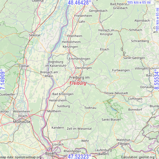
Freiburg GPS coordinates[2]
47° 59' 45.24" North, 7° 51' 7.992" East
| Map corner | latitude | longitude |
|---|---|---|
| Upper-left | 48.46428°, | 7.14909° |
| Center: | 47.9959°, | 7.85222° |
| Lower-right: | 47.52323°, | 8.55534° |
| Map W x H: | 104.6×104.6 km | = 65×65mi |
| max Lat: | 55.01917° ⇑95.6% North |
| Freiburg: | 47.9959° |
| min Lat: | ⇓4.4% South 47.40724° |
| min Long | Freiburg | max Long |
| 5.92978° | 7.85222° | 14.98853° |
| W 20.1%⇐ | ⇒79.9% E |
Elevation
Elevation of Freiburg is 279 m = 915 ft, and this is 29.9 m = 98 ft above average elevation for this country.
| Max E: |
1256 m = 4121 ft | 41.9% |
| Freiburg | 279 m 915 ft | |
| Avg. | 249.1 m = 817 ft | |
Min E: |
-5 m = -16 ft | 58.1% |
See also: Freiburg elevation on elevation.city.
Geographical zone
Freiburg is located in North temperate zone (between Tropic of Cancer and the Arctic Circle). Distance of this North polar circle is 2064.5 km =1282.8 mi to North.| Distance of | km | miles | from Freiburg |
|---|---|---|---|
| North Pole | 4670.4 | 2902.1 | to North |
| Arctic Circle | 2064.5 | 1282.8 | to North |
| Tropic Cancer | 2730.7 | 1696.8 | to South |
| Equator | 5336.6 | 3316 | to South |


Nearby cities:
15 places around Freiburg: (largest is in red/bold)
• Au
5.3 km =3.3 mi,  195°
195°
• Buchheim
9.2 km =5.7 mi,  320°
320°
• Denzlingen
8.2 km =5.1 mi,  16°
16°
• Ebringen
7 km =4.3 mi,  233°
233°
• Gundelfingen
5.3 km =3.3 mi,  10°
10°
• Heuweiler
7 km =4.3 mi,  30°
30°
• Horben
7 km =4.3 mi,  171°
171°
• Kirchzarten
8 km =5 mi,  114°
114°
• Merzhausen
3.5 km =2.2 mi, 203°
• Schallstadt
8.2 km =5.1 mi,  239°
239°
• Stegen
8.6 km =5.3 mi,  99°
99°
• Sölden
7.4 km =4.6 mi, 200°
• Umkirch
7.6 km =4.7 mi,  303°
303°
• Vörstetten
7.9 km =4.9 mi,  358°
358°
• Wittnau
5.7 km =3.5 mi,  207°
207°
In other languages:
- In Spanish: Friburgo de Brisgovia
- In France: Fribourg-en-Brisgau
- In German: Freiburg im Breisgau
- In Italian: Friburgo in Brisgovia
- In Russian: Фрайбург-им-Брайсгау
Sources, notices
• [Note1] Compared only with cities in Germany existing in our database
• [Src1] Map data: © OpenStreetMap contributors (CC-BY-SA)
• [Src2] Other city data from geonames.org with taken over terms of usage.
• [Src3] Geographical zone / Annual Mean Temperature by Robert A. Rohde @ Wikipedia
