Glottertal geodata
Glottertal (Baden-Württemberg) is a seat of a fourth-order administrative division; located in Germany in Europe/Berlin (GMT+2) time zone. In our database, there are 11009 cities with bigger population. Compared to other cities in Germany, 94.8% of cities are located further ↑North; 77.9% of cities are located further →East and 75.7% of cities have lower elevation than Glottertal. Note1
Administrative division(s):
- Level 1: Baden-Württemberg
- Level 2: Freiburg Region
- Level 3: Landkreis Breisgau-Hochschwarzwald
- Level 4: Glottertal


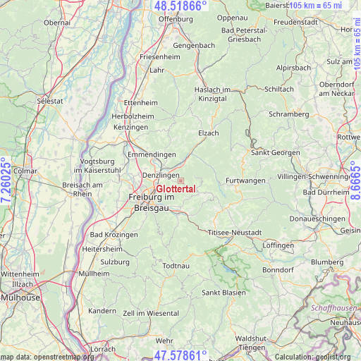
Glottertal GPS coordinates[2]
48° 3' 2.808" North, 7° 57' 48.132" East
| Map corner | latitude | longitude |
|---|---|---|
| Upper-left | 48.51866°, | 7.26025° |
| Center: | 48.05078°, | 7.96337° |
| Lower-right: | 47.57861°, | 8.6665° |
| Map W x H: | 104.5×104.5 km | = 64.9×64.9mi |
| max Lat: | 55.01917° ⇑94.8% North |
| Glottertal: | 48.05078° |
| min Lat: | ⇓5.2% South 47.40724° |
| min Long | Glottertal | max Long |
| 5.92978° | 7.96337° | 14.98853° |
| W 22.1%⇐ | ⇒77.9% E |
Elevation
Elevation of Glottertal is 403 m = 1322 ft, and this is 153.9 m = 505 ft above average elevation for this country.
| Max E: |
1256 m = 4121 ft | 24.3% |
| Glottertal | 403 m 1322 ft | |
| Avg. | 249.1 m = 817 ft | |
Min E: |
-5 m = -16 ft | 75.7% |
See also: Germany elevation on elevation.city.
Geographical zone
Glottertal is located in North temperate zone (between Tropic of Cancer and the Arctic Circle). Distance of this North polar circle is 2058.4 km =1279 mi to North.| Distance of | km | miles | from Glottertal |
|---|---|---|---|
| North Pole | 4664.3 | 2898.3 | to North |
| Arctic Circle | 2058.4 | 1279 | to North |
| Tropic Cancer | 2736.8 | 1700.6 | to South |
| Equator | 5342.7 | 3319.8 | to South |


Nearby cities:
15 places around Glottertal: (largest is in red/bold)
• Buchenbach
10.5 km =6.5 mi,  161°
161°
• Denzlingen
6.2 km =3.9 mi,  286°
286°
• Emmendingen
11.3 km =7 mi,  313°
313°
• Freiburg
10.3 km =6.4 mi,  233°
233°
• Gundelfingen
7.3 km =4.5 mi,  262°
262°
• Gutach im Breisgau
7.5 km =4.7 mi,  11°
11°
• Heuweiler
4.7 km =2.9 mi,  268°
268°
• Kirchzarten
9.4 km =5.8 mi,  186°
186°
• Sankt Märgen
10.7 km =6.6 mi,  116°
116°
• Sankt Peter
6.5 km =4 mi,  127°
127°
• Sexau
7.1 km =4.4 mi,  323°
323°
• St. Peter
6.4 km =4 mi, 126°
• Stegen
7.5 km =4.7 mi,  178°
178°
• Vörstetten
8.6 km =5.3 mi,  281°
281°
• Waldkirch
5 km =3.1 mi,  0°
0°
Sources, notices
• [Note1] Compared only with cities in Germany existing in our database
• [Src1] Map data: © OpenStreetMap contributors (CC-BY-SA)
• [Src2] Other city data from geonames.org with taken over terms of usage.
• [Src3] Geographical zone / Annual Mean Temperature by Robert A. Rohde @ Wikipedia
