Gundelfingen geodata
Gundelfingen (Baden-Württemberg) is a seat of a fourth-order administrative division; located in Germany in Europe/Berlin (GMT+2) time zone. With population of 11,563 people, there are 1422 cities with bigger population in this country. Compared to other cities in Germany, 95% of cities are located further ↑North; 79.8% of cities are located further →East and 51.3% of cities have lower elevation than Gundelfingen. Note1
Administrative division(s):
- Level 1: Baden-Württemberg
- Level 2: Freiburg Region
- Level 3: Landkreis Breisgau-Hochschwarzwald
- Level 4: Gundelfingen


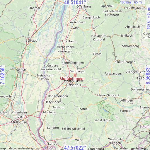
Gundelfingen GPS coordinates[2]
48° 2' 32.856" North, 7° 51' 56.52" East
| Map corner | latitude | longitude |
|---|---|---|
| Upper-left | 48.51041°, | 7.16258° |
| Center: | 48.04246°, | 7.8657° |
| Lower-right: | 47.57022°, | 8.56883° |
| Map W x H: | 104.5×104.5 km | = 64.9×64.9mi |
| max Lat: | 55.01917° ⇑95% North |
| Gundelfingen: | 48.04246° |
| min Lat: | ⇓5% South 47.40724° |
| min Long | Gundelfingen | max Long |
| 5.92978° | 7.8657° | 14.98853° |
| W 20.2%⇐ | ⇒79.8% E |
Elevation
Elevation of Gundelfingen is 235 m = 771 ft, and this is 14.1 m = 46 ft below average elevation for this country.
| Max E: |
1256 m = 4121 ft | 48.7% |
| Avg. | 249.1 m = 817 ft | |
| Gundelfingen | 235 m = 771 ft | |
Min E: |
-5 m = -16 ft | 51.3% |
See also: Germany elevation on elevation.city.
Geographical zone
Gundelfingen is located in North temperate zone (between Tropic of Cancer and the Arctic Circle). Distance of this North polar circle is 2059.4 km =1279.7 mi to North.| Distance of | km | miles | from Gundelfingen |
|---|---|---|---|
| North Pole | 4665.2 | 2898.8 | to North |
| Arctic Circle | 2059.4 | 1279.7 | to North |
| Tropic Cancer | 2735.9 | 1700 | to South |
| Equator | 5341.8 | 3319.2 | to South |


Nearby cities:
15 places around Gundelfingen: (largest is in red/bold)
• Buchheim
7.2 km =4.5 mi,  285°
285°
• Denzlingen
3 km =1.9 mi,  25°
25°
• Emmendingen
8.8 km =5.5 mi,  354°
354°
• Freiburg
5.3 km =3.3 mi,  190°
190°
• Glottertal
7.3 km =4.5 mi,  82°
82°
• Gottenheim
9.9 km =6.2 mi,  274°
274°
• Heuweiler
2.7 km =1.7 mi,  71°
71°
• Kirchzarten
10.5 km =6.5 mi,  143°
143°
• Merzhausen
8.8 km =5.5 mi,  195°
195°
• Sexau
7.3 km =4.5 mi, 25°
• Stegen
10 km =6.2 mi,  131°
131°
• Teningen
10.5 km =6.5 mi,  337°
337°
• Umkirch
7.4 km =4.6 mi,  262°
262°
• Vörstetten
2.9 km =1.8 mi, 336°
• Waldkirch
9.4 km =5.8 mi,  50°
50°
Sources, notices
• [Note1] Compared only with cities in Germany existing in our database
• [Src1] Map data: © OpenStreetMap contributors (CC-BY-SA)
• [Src2] Other city data from geonames.org with taken over terms of usage.
• [Src3] Geographical zone / Annual Mean Temperature by Robert A. Rohde @ Wikipedia
