Stegaurach geodata
Stegaurach (Bavaria) is a seat of a fourth-order administrative division; located in Germany in Europe/Berlin (GMT+2) time zone. With population of 6,804 people, there are 2234 cities with bigger population in this country. Compared to other cities in Germany, 67.4% of cities are located further ↑North; 64.7% of cities are located further ←West and 59.5% of cities have lower elevation than Stegaurach. Note1
Administrative division(s):
- Level 1: Bavaria
- Level 2: Upper Franconia
- Level 3: Landkreis Bamberg
- Level 4: Stegaurach


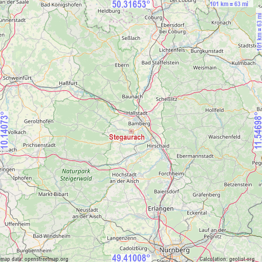
Stegaurach GPS coordinates[2]
49° 51' 55.548" North, 10° 50' 37.86" East
| Map corner | latitude | longitude |
|---|---|---|
| Upper-left | 50.31653°, | 10.14073° |
| Center: | 49.86543°, | 10.84385° |
| Lower-right: | 49.41008°, | 11.54698° |
| Map W x H: | 100.8×100.8 km | = 62.6×62.6mi |
| max Lat: | 55.01917° ⇑67.4% North |
| Stegaurach: | 49.86543° |
| min Lat: | ⇓32.6% South 47.40724° |
| min Long | Stegaurach | max Long |
| 5.92978° | 10.84385° | 14.98853° |
| W 64.7%⇐ | ⇒35.3% E |
Elevation
Elevation of Stegaurach is 287 m = 942 ft, and this is 37.9 m = 124 ft above average elevation for this country.
| Max E: |
1256 m = 4121 ft | 40.5% |
| Stegaurach | 287 m 942 ft | |
| Avg. | 249.1 m = 817 ft | |
Min E: |
-5 m = -16 ft | 59.5% |
See also: Germany elevation on elevation.city.
Geographical zone
Stegaurach is located in North temperate zone (between Tropic of Cancer and the Arctic Circle). Distance of this North polar circle is 1856.7 km =1153.7 mi to North.| Distance of | km | miles | from Stegaurach |
|---|---|---|---|
| North Pole | 4462.5 | 2772.9 | to North |
| Arctic Circle | 1856.7 | 1153.7 | to North |
| Tropic Cancer | 2938.6 | 1826 | to South |
| Equator | 5544.5 | 3445.2 | to South |


Nearby cities:
15 places around Stegaurach: (largest is in red/bold)
• Bamberg
5.5 km =3.4 mi,  47°
47°
• Bischberg
5.1 km =3.2 mi,  350°
350°
• Burgebrach
8.3 km =5.2 mi,  240°
240°
• Frensdorf
5.7 km =3.5 mi,  163°
163°
• Gundelsheim
9.7 km =6 mi,  34°
34°
• Hallstadt
7.4 km =4.6 mi,  17°
17°
• Kemmern
10.2 km =6.3 mi,  13°
13°
• Memmelsdorf
11 km =6.8 mi, 48°
• Oberhaid
7.7 km =4.8 mi,  344°
344°
• Pettstadt
7.2 km =4.5 mi,  123°
123°
• Pommersfelden
11.2 km =7 mi,  190°
190°
• Priesendorf
10.6 km =6.6 mi,  296°
296°
• Strullendorf
9.5 km =5.9 mi,  104°
104°
• Viereth-Trunstadt
7.9 km =4.9 mi,  322°
322°
• Walsdorf
4.3 km =2.7 mi,  271°
271°
Sources, notices
• [Note1] Compared only with cities in Germany existing in our database
• [Src1] Map data: © OpenStreetMap contributors (CC-BY-SA)
• [Src2] Other city data from geonames.org with taken over terms of usage.
• [Src3] Geographical zone / Annual Mean Temperature by Robert A. Rohde @ Wikipedia
