Strullendorf geodata
Strullendorf (Bavaria) is a seat of a fourth-order administrative division; located in Germany in Europe/Berlin (GMT+2) time zone. With population of 7,926 people, there are 1966 cities with bigger population in this country. Compared to other cities in Germany, 67.9% of cities are located further ↑North; 66.6% of cities are located further ←West and 54.3% of cities have lower elevation than Strullendorf. Note1
Administrative division(s):
- Level 1: Bavaria
- Level 2: Upper Franconia
- Level 3: Landkreis Bamberg
- Level 4: Strullendorf


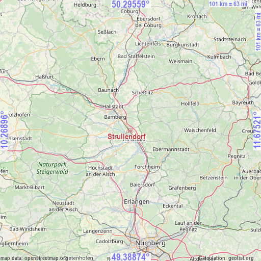
Strullendorf GPS coordinates[2]
49° 50' 39.444" North, 10° 58' 19.488" East
| Map corner | latitude | longitude |
|---|---|---|
| Upper-left | 50.29559°, | 10.26896° |
| Center: | 49.84429°, | 10.97208° |
| Lower-right: | 49.38874°, | 11.67521° |
| Map W x H: | 100.8×100.8 km | = 62.6×62.6mi |
| max Lat: | 55.01917° ⇑67.9% North |
| Strullendorf: | 49.84429° |
| min Lat: | ⇓32.1% South 47.40724° |
| min Long | Strullendorf | max Long |
| 5.92978° | 10.97208° | 14.98853° |
| W 66.6%⇐ | ⇒33.4% E |
Elevation
Elevation of Strullendorf is 254 m = 833 ft, and this is 4.9 m = 16 ft above average elevation for this country.
| Max E: |
1256 m = 4121 ft | 45.7% |
| Strullendorf | 254 m 833 ft | |
| Avg. | 249.1 m = 817 ft | |
Min E: |
-5 m = -16 ft | 54.3% |
See also: Germany elevation on elevation.city.
Geographical zone
Strullendorf is located in North temperate zone (between Tropic of Cancer and the Arctic Circle). Distance of this North polar circle is 1859 km =1155.1 mi to North.| Distance of | km | miles | from Strullendorf |
|---|---|---|---|
| North Pole | 4464.9 | 2774.4 | to North |
| Arctic Circle | 1859 | 1155.1 | to North |
| Tropic Cancer | 2936.2 | 1824.5 | to South |
| Equator | 5542.2 | 3443.8 | to South |


Nearby cities:
15 places around Strullendorf: (largest is in red/bold)
• Altendorf
5.9 km =3.7 mi,  146°
146°
• Bamberg
7.9 km =4.9 mi,  319°
319°
• Bischberg
12.5 km =7.8 mi,  306°
306°
• Buttenheim
6.1 km =3.8 mi,  137°
137°
• Eggolsheim
10.3 km =6.4 mi, 143°
• Frensdorf
8.2 km =5.1 mi,  247°
247°
• Gundelsheim
11 km =6.8 mi,  340°
340°
• Hallerndorf
9.5 km =5.9 mi,  176°
176°
• Hallstadt
11.7 km =7.3 mi, 323°
• Hirschaid
3.2 km =2 mi,  157°
157°
• Litzendorf
8.3 km =5.2 mi,  19°
19°
• Memmelsdorf
9.6 km =6 mi,  354°
354°
• Pettstadt
3.5 km =2.2 mi,  243°
243°
• Stegaurach
9.5 km =5.9 mi,  284°
284°
• Walsdorf
13.8 km =8.6 mi, 280°
Sources, notices
• [Note1] Compared only with cities in Germany existing in our database
• [Src1] Map data: © OpenStreetMap contributors (CC-BY-SA)
• [Src2] Other city data from geonames.org with taken over terms of usage.
• [Src3] Geographical zone / Annual Mean Temperature by Robert A. Rohde @ Wikipedia
