Stallwang geodata
Stallwang (Bavaria) is a seat of a fourth-order administrative division; located in Germany in Europe/Berlin (GMT+2) time zone. In our database, there are 11009 cities with bigger population. Compared to other cities in Germany, 82.4% of cities are located further ↑North; 89.4% of cities are located further ←West and 70.3% of cities have lower elevation than Stallwang. Note1
Administrative division(s):
- Level 1: Bavaria
- Level 2: Lower Bavaria
- Level 3: Landkreis Straubing-Bogen
- Level 4: Stallwang


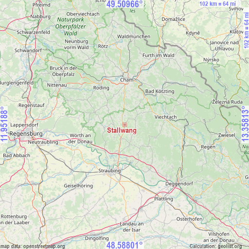
Stallwang GPS coordinates[2]
49° 3' 3.492" North, 12° 39' 18" East
| Map corner | latitude | longitude |
|---|---|---|
| Upper-left | 49.50966°, | 11.95188° |
| Center: | 49.05097°, | 12.655° |
| Lower-right: | 48.58801°, | 13.35813° |
| Map W x H: | 102.5×102.5 km | = 63.7×63.7mi |
| max Lat: | 55.01917° ⇑82.4% North |
| Stallwang: | 49.05097° |
| min Lat: | ⇓17.6% South 47.40724° |
| min Long | Stallwang | max Long |
| 5.92978° | 12.655° | 14.98853° |
| W 89.4%⇐ | ⇒10.6% E |
Elevation
Elevation of Stallwang is 360 m = 1181 ft, and this is 110.9 m = 364 ft above average elevation for this country.
| Max E: |
1256 m = 4121 ft | 29.7% |
| Stallwang | 360 m 1181 ft | |
| Avg. | 249.1 m = 817 ft | |
Min E: |
-5 m = -16 ft | 70.3% |
See also: Germany elevation on elevation.city.
Geographical zone
Stallwang is located in North temperate zone (between Tropic of Cancer and the Arctic Circle). Distance of this North polar circle is 1947.2 km =1209.9 mi to North.| Distance of | km | miles | from Stallwang |
|---|---|---|---|
| North Pole | 4553.1 | 2829.2 | to North |
| Arctic Circle | 1947.2 | 1209.9 | to North |
| Tropic Cancer | 2848 | 1769.7 | to South |
| Equator | 5454 | 3389 | to South |


Nearby cities:
15 places around Stallwang: (largest is in red/bold)
• Ascha
5.9 km =3.7 mi,  195°
195°
• Falkenfels
6.8 km =4.2 mi,  220°
220°
• Haibach
5.3 km =3.3 mi,  124°
124°
• Haselbach
5.9 km =3.7 mi,  153°
153°
• Konzell
4.7 km =2.9 mi,  59°
59°
• Loitzendorf
3.7 km =2.3 mi,  1°
1°
• Michelsneukirchen
10.9 km =6.8 mi,  317°
317°
• Mitterfels
8.5 km =5.3 mi,  168°
168°
• Neukirchen
11.2 km =7 mi,  139°
139°
• Rattenberg
7.9 km =4.9 mi, 60°
• Rattiszell
2.8 km =1.7 mi, 173°
• Steinach
11.3 km =7 mi, 197°
• Traitsching
11 km =6.8 mi,  358°
358°
• Wiesenfelden
8.5 km =5.3 mi,  262°
262°
• Zandt
12.4 km =7.7 mi,  27°
27°
Sources, notices
• [Note1] Compared only with cities in Germany existing in our database
• [Src1] Map data: © OpenStreetMap contributors (CC-BY-SA)
• [Src2] Other city data from geonames.org with taken over terms of usage.
• [Src3] Geographical zone / Annual Mean Temperature by Robert A. Rohde @ Wikipedia
