Zandt geodata
Zandt (Bavaria) is a seat of a fourth-order administrative division; located in Germany in Europe/Berlin (GMT+2) time zone. With population of 1,875 people, there are 5237 cities with bigger population in this country. Compared to other cities in Germany, 81.2% of cities are located further ↑North; 90.1% of cities are located further ←West and 83.3% of cities have lower elevation than Zandt. Note1
Administrative division(s):
- Level 1: Bavaria
- Level 2: Upper Palatinate
- Level 3: Landkreis Cham
- Level 4: Zandt


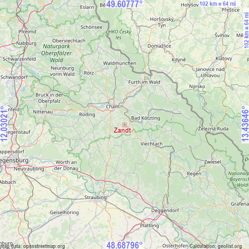
Zandt GPS coordinates[2]
49° 9' 0" North, 12° 43' 59.988" East
| Map corner | latitude | longitude |
|---|---|---|
| Upper-left | 49.60777°, | 12.03021° |
| Center: | 49.15°, | 12.73333° |
| Lower-right: | 48.68796°, | 13.43646° |
| Map W x H: | 102.3×102.3 km | = 63.6×63.6mi |
| max Lat: | 55.01917° ⇑81.2% North |
| Zandt: | 49.15° |
| min Lat: | ⇓18.8% South 47.40724° |
| min Long | Zandt | max Long |
| 5.92978° | 12.73333° | 14.98853° |
| W 90.1%⇐ | ⇒9.9% E |
Elevation
Elevation of Zandt is 456 m = 1496 ft, and this is 206.9 m = 679 ft above average elevation for this country.
| Max E: |
1256 m = 4121 ft | 16.7% |
| Zandt | 456 m 1496 ft | |
| Avg. | 249.1 m = 817 ft | |
Min E: |
-5 m = -16 ft | 83.3% |
See also: Germany elevation on elevation.city.
Geographical zone
Zandt is located in North temperate zone (between Tropic of Cancer and the Arctic Circle). Distance of this North polar circle is 1936.2 km =1203.1 mi to North.| Distance of | km | miles | from Zandt |
|---|---|---|---|
| North Pole | 4542.1 | 2822.3 | to North |
| Arctic Circle | 1936.2 | 1203.1 | to North |
| Tropic Cancer | 2859 | 1776.5 | to South |
| Equator | 5465 | 3395.8 | to South |


Nearby cities:
15 places around Zandt: (largest is in red/bold)
• Blaibach
6.3 km =3.9 mi,  72°
72°
• Cham
10.2 km =6.3 mi,  325°
325°
• Chamerau
5.7 km =3.5 mi,  12°
12°
• Grafenwiesen
12.2 km =7.6 mi,  62°
62°
• Konzell
8.8 km =5.5 mi,  190°
190°
• Kötzting
9.3 km =5.8 mi, 71°
• Loitzendorf
9.2 km =5.7 mi,  217°
217°
• Miltach
2.9 km =1.8 mi, 62°
• Prackenbach
9.1 km =5.7 mi,  131°
131°
• Rattenberg
7.2 km =4.5 mi,  170°
170°
• Runding
7.5 km =4.7 mi,  16°
16°
• Schorndorf
10.3 km =6.4 mi,  276°
276°
• Stallwang
12.4 km =7.7 mi,  207°
207°
• Traitsching
6.1 km =3.8 mi,  270°
270°
• Willmering
12.1 km =7.5 mi,  336°
336°
Sources, notices
• [Note1] Compared only with cities in Germany existing in our database
• [Src1] Map data: © OpenStreetMap contributors (CC-BY-SA)
• [Src2] Other city data from geonames.org with taken over terms of usage.
• [Src3] Geographical zone / Annual Mean Temperature by Robert A. Rohde @ Wikipedia
