Rattiszell geodata
Rattiszell (Bavaria) is a seat of a fourth-order administrative division; located in Germany in Europe/Berlin (GMT+2) time zone. With population of 1,412 people, there are 6056 cities with bigger population in this country. Compared to other cities in Germany, 82.7% of cities are located further ↑North; 89.4% of cities are located further ←West and 69.5% of cities have lower elevation than Rattiszell. Note1
Administrative division(s):
- Level 1: Bavaria
- Level 2: Lower Bavaria
- Level 3: Landkreis Straubing-Bogen
- Level 4: Rattiszell


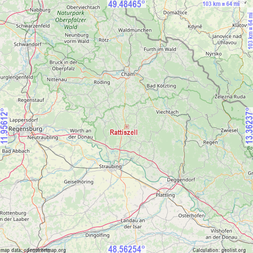
Rattiszell GPS coordinates[2]
49° 1' 32.628" North, 12° 39' 33.264" East
| Map corner | latitude | longitude |
|---|---|---|
| Upper-left | 49.48465°, | 11.95612° |
| Center: | 49.02573°, | 12.65924° |
| Lower-right: | 48.56254°, | 13.36237° |
| Map W x H: | 102.5×102.5 km | = 63.7×63.7mi |
| max Lat: | 55.01917° ⇑82.7% North |
| Rattiszell: | 49.02573° |
| min Lat: | ⇓17.3% South 47.40724° |
| min Long | Rattiszell | max Long |
| 5.92978° | 12.65924° | 14.98853° |
| W 89.4%⇐ | ⇒10.6% E |
Elevation
Elevation of Rattiszell is 355 m = 1165 ft, and this is 105.9 m = 347 ft above average elevation for this country.
| Max E: |
1256 m = 4121 ft | 30.5% |
| Rattiszell | 355 m 1165 ft | |
| Avg. | 249.1 m = 817 ft | |
Min E: |
-5 m = -16 ft | 69.5% |
See also: Germany elevation on elevation.city.
Geographical zone
Rattiszell is located in North temperate zone (between Tropic of Cancer and the Arctic Circle). Distance of this North polar circle is 1950 km =1211.7 mi to North.| Distance of | km | miles | from Rattiszell |
|---|---|---|---|
| North Pole | 4555.9 | 2830.9 | to North |
| Arctic Circle | 1950 | 1211.7 | to North |
| Tropic Cancer | 2845.2 | 1767.9 | to South |
| Equator | 5451.2 | 3387.2 | to South |


Nearby cities:
15 places around Rattiszell: (largest is in red/bold)
• Ascha
3.4 km =2.1 mi,  213°
213°
• Falkenfels
5.3 km =3.3 mi,  242°
242°
• Haibach
4.1 km =2.5 mi,  92°
92°
• Haselbach
3.4 km =2.1 mi,  136°
136°
• Hunderdorf
10 km =6.2 mi,  147°
147°
• Kirchroth
11.6 km =7.2 mi,  223°
223°
• Konzell
6.4 km =4 mi,  36°
36°
• Loitzendorf
6.5 km =4 mi,  357°
357°
• Mitterfels
5.7 km =3.5 mi,  165°
165°
• Neukirchen
9 km =5.6 mi,  128°
128°
• Rattenberg
9.4 km =5.8 mi, 44°
• Stallwang
2.8 km =1.7 mi,  353°
353°
• Steinach
8.8 km =5.5 mi, 205°
• Wiesenfelden
8.8 km =5.5 mi,  280°
280°
• Windberg
11.2 km =7 mi, 145°
Sources, notices
• [Note1] Compared only with cities in Germany existing in our database
• [Src1] Map data: © OpenStreetMap contributors (CC-BY-SA)
• [Src2] Other city data from geonames.org with taken over terms of usage.
• [Src3] Geographical zone / Annual Mean Temperature by Robert A. Rohde @ Wikipedia
