Stadtallendorf geodata
Stadtallendorf (Hesse) is a populated place; located in Germany in Europe/Berlin (GMT+2) time zone. With population of 21,720 people, there are 694 cities with bigger population in this country. Compared to other cities in Germany, 54.7% of cities are located further ↓South; 65.2% of cities are located further →East and 52.2% of cities have lower elevation than Stadtallendorf. Note1
Administrative division(s):
- Level 1: Hesse
- Level 2: Regierungsbezirk Gießen
- Level 3: Landkreis Marburg-Biedenkopf
- Level 4: Stadtallendorf


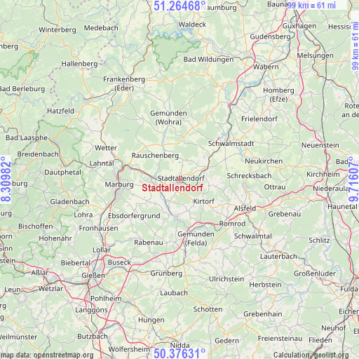
Stadtallendorf GPS coordinates[2]
50° 49' 21.396" North, 9° 0' 46.584" East
| Map corner | latitude | longitude |
|---|---|---|
| Upper-left | 51.26468°, | 8.30982° |
| Center: | 50.82261°, | 9.01294° |
| Lower-right: | 50.37631°, | 9.71607° |
| Map W x H: | 98.8×98.8 km | = 61.4×61.4mi |
| max Lat: | 55.01917° ⇑45.3% North |
| Stadtallendorf: | 50.82261° |
| min Lat: | ⇓54.7% South 47.40724° |
| min Long | Stadtallendorf | max Long |
| 5.92978° | 9.01294° | 14.98853° |
| W 34.8%⇐ | ⇒65.2% E |
Elevation
Elevation of Stadtallendorf is 241 m = 791 ft, and this is 8.1 m = 27 ft below average elevation for this country.
| Max E: |
1256 m = 4121 ft | 47.8% |
| Avg. | 249.1 m = 817 ft | |
| Stadtallendorf | 241 m = 791 ft | |
Min E: |
-5 m = -16 ft | 52.2% |
See also: Germany elevation on elevation.city.
Geographical zone
Stadtallendorf is located in North temperate zone (between Tropic of Cancer and the Arctic Circle). Distance of this North polar circle is 1750.2 km =1087.5 mi to North.| Distance of | km | miles | from Stadtallendorf |
|---|---|---|---|
| North Pole | 4356.1 | 2706.8 | to North |
| Arctic Circle | 1750.2 | 1087.5 | to North |
| Tropic Cancer | 3045 | 1892.1 | to South |
| Equator | 5650.9 | 3511.3 | to South |


Nearby cities:
15 places around Stadtallendorf: (largest is in red/bold)
• Amöneburg
7 km =4.3 mi,  244°
244°
• Cölbe
16.6 km =10.3 mi,  280°
280°
• Ebsdorfergrund
15.3 km =9.5 mi,  225°
225°
• Gemünden an der Wohra
17.1 km =10.6 mi,  349°
349°
• Gilserberg
14.7 km =9.1 mi,  14°
14°
• Homberg
10.2 km =6.3 mi,  186°
186°
• Höingen
13.2 km =8.2 mi,  209°
209°
• Kirchhain
6 km =3.7 mi,  274°
274°
• Kirtorf
8.7 km =5.4 mi,  132°
132°
• Marburg an der Lahn
17.1 km =10.6 mi,  264°
264°
• Neustadt (Hessen)
7.9 km =4.9 mi,  67°
67°
• Niederklein
3.4 km =2.1 mi,  199°
199°
• Rauschenberg
9.5 km =5.9 mi,  315°
315°
• Schwalmstadt
18.9 km =11.7 mi,  49°
49°
• Willingshausen
13.5 km =8.4 mi,  76°
76°
Sources, notices
• [Note1] Compared only with cities in Germany existing in our database
• [Src1] Map data: © OpenStreetMap contributors (CC-BY-SA)
• [Src2] Other city data from geonames.org with taken over terms of usage.
• [Src3] Geographical zone / Annual Mean Temperature by Robert A. Rohde @ Wikipedia
